Daisy Low Falls, Indiana

Daisy Low Falls in May 2017

There are waterfalls in Indiana, and while smaller, some of them can be very fun to visit. In the Kokiwanee Nature Preserve, there are three falls. Check out Kissing Falls for more info about where I parked and started along the trail.

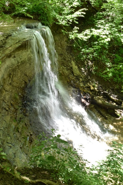
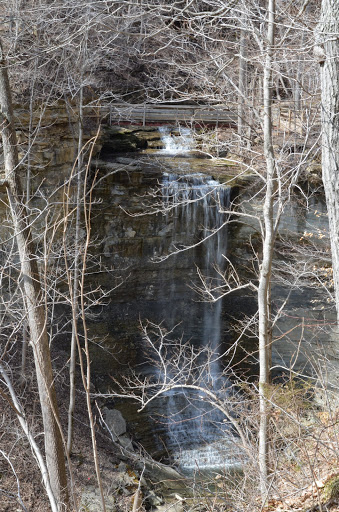
Daisy Low Falls is the second waterfall I encountered, and I was able to capture some good pictures of this waterfall. Frog Falls was the most difficult to capture. I somehow knew to look for Daisy Low Falls, even though it doesn’t show up on the current Kokiwanee ACRES Land Trust map. ACRES takes care of the lands here. Their map shows Frog Falls, and I know that Daisy Low Falls was in between Kissing and Frog Falls, Kissing being the first waterfall I found along the trail.

There’s a trail that follows the Salamonie River, and that’s the one that I took to find Daisy Low Falls. ACRES land trust still rates this as a more difficult hike, though I believe they’re referring to the a much larger loop you can take. I did not find it to be a difficult hike or trail to the falls, though I remember doing some uphill hiking on one of the trails to find Frog Falls. The one thing I would caution: It was very muddy on the day I arrived at the preserve. It had rained the day before, so I had to be careful not to slip, but that was the main issue. I don’t remember climbing much uphill.

Directions:

  1. This is an instance where there’s not an obvious starting point. You can approach from multiple directions. It’s in between Wabash and Huntington south of US-24.
  2. The official entrance to the park is off of E 50 S (GPS at 5825 E 50 S, Lagro, IN 46941). I instead went to the intersection of E 50 S and Stone Road, and went south on Stone Road, turned right onto the road that led to the Salamonie River Boat Launch (can’t remember if there was a more specific name).
  3. At the end of this road, there’s a parking area. The trail to the falls starts at the end of the parking area (read above).

Accessibility: 9/10 (easy)
Height: 10′
Length of Hike: 0.3 miles round-trip

Where in the World is Daisy Low Falls?

Tunnel Falls, Indiana

Clifty Falls State Park in Indiana (right near the Kentucky border) has four waterfalls that are 60+’ tall. It’s actually an impressive sight, as your brain may not associate Indiana with waterfalls, or especially tall waterfalls. The tallest waterfall in the park, at 83′, is Tunnel Falls.

I’m not sure what the perfect time to show up at the park is. I went in March 2014 and it had rained a bit, so most of the falls were at least running in the park. I noticed, though, that many of the falls are partially blocked by trees, so sometime when the trees don’t have leaves might be best. Now, there are a number of trails that lead to the base of some of the falls, but some of these hikes are long and/or strenuous, so I didn’t do any of those hikes (or wasn’t very successful at finding the trails). So you can view the four falls with shorter hikes, but you just won’t be able to guarantee the greatest of views. It’s still worth a visit if you’re in the area.

Directions:

  1. There are two entrances to the park, and both are found between Hanover and Madison. The north entrance is off of IN-62. The south entrance is off of IN-56. Both will get you to the waterfalls, as the road loops around the park.
  2. The north entrance will get you to the viewpoint for Tunnel Falls slightly quicker. (If you are heading east along IN-62, you would turn right into the park at the north entrance.)
  3. If I remember correctly, there are pretty clear signs for each of the falls. There may be two parking areas that you can view Tunnel Falls, with one on the north side (Hickory Grove), and one on the south side directly opposite. I think the photo below is from the south parking area.

Accessibility: 9/10 (easy)
Height: 83′
Length of Hike: 0.2 miles round-trip

Tunnel Falls Indiana (11)

Tunnel Falls in March 2014

Where in the World is Tunnel Falls?

Ross Run Falls, Indiana

Waterfalls in Indiana are somewhat scattered throughout the state. You’ll find a few in one area, a few in another, making it kind of difficult to coordinate seeing a number of them at once. In northern Indiana, you’ll find a number of small yet interesting waterfalls within a few miles of each other. This waterfall is found at the Hathaway Preserve at Ross Run, while the other are found in nearby Salamonie River State Forest and Kokiwanee Nature Preserve.

I visited in May and I believe it had rained just the day before. (It was beautifully sunny when I was hiking to see the falls.) Many of the falls that wouldn’t normally be there were showing up. At the same time, this meant that some of the trails were very muddy and in some cases impassible. I did a lot of hiking up slippery slopes. Ross Run Falls definitely qualifies as the easier of the waterfalls to find, with relatively flat hiking terrain.

You might notice that the water looks very, very cloudy. Runoff from the rain definitely made the water opaque. It was fascinating to see the water in such a state. While this waterfall isn’t particularly tall, it was fun to find waterfalls in an area of the state that you might not otherwise expect waterfalls.

Directions:

  1. There are a number of ways to get to the preserve, either from the cities of Wabash or Lagro, or from the other two preserves. It might be easiest to explain directions from Lagro.
  2. From Lagro, head south on IN-524.
  3. IN-524 will head south, veer east for a short ways, and then head south again. Make sure to stay on IN-524.
  4. After maybe a mile, you’ll come to E Baumbauer Road on your right. Turn right here.
  5. After approximately 1.5 miles, you’ll come to Hathaway Preserve. It will be a circular gravel parking area on your right (assuming you’re heading west).
  6. From the parking area, the hike to the falls isn’t particularly difficult.

Accessibility: 8/10 (easy/moderate)
Height: 6′
Length of Hike: 0.7 miles round-trip

DSC_0268

Ross Run Falls in May 2017

Where in the World is Ross Run Falls?

Kissing Falls, Indiana

DSC_0046
Kissing Falls in late May 2017

I had the chance to visit Indiana this past weekend, and decided to try and find some lesser-known waterfalls in northern Indiana. It took a bit more searching, but I discovered there were three locations within very close proximity that each had waterfalls. And you can visit all of these locations and waterfalls in just a few hours.

The first location I stopped at was Kokiwanee Nature Preserve. (Other falls can be found in Salamonie State Forest and Hathaway Preserve at Ross Run.) It has three named waterfalls: Kissing Falls, Daisy Low Falls, and Frog Falls. I had a sense some of these waterfalls might be seasonal, but as I was driving to the preserve, I saw many farm fields that had pools of water…this was a good sign.

I decided to enter the preserve from the less advertised starting point: a boat launch off of Stone Road. After looking at a map, I realized this might be a quicker way to reach all 3 falls. And it is, especially for Kissing Falls. When you get out of the car at the end of the parking lot, there will be a faint trail at the forest edge. This leads very quickly to the falls. (There is another trail that seems to lead to the falls further down the parking lot, but a sign says to go this other trail at the end…so respect that request.)

It was a short hike, about 0.1 miles one-way. As I followed the faint trail at the end of the parking lot, it quickly connects to a set of “stairs” (the ground has been groomed with pieces of wood to create these “stairs”). If you turn left and head uphill, you’ll again quickly see a sign that directs you to the waterfall trail. There’s a sign that says the hike is difficult, but I’m not really sure what they’re referring to. I guess if you head downhill and try to get to the base of the falls by hiking up the stream (if that’s allowed), it might be a bit more difficult. I wasn’t feeling particularly great, and decided to follow the trail that ran parallel to the creek. After a very short distance, I came to Kissing Falls (looking at it from above). I felt this was a fine enough view to take some shots and head to the other falls in the park. Because of recent rains, the falls were flowing pretty well, though I couldn’t avoid the afternoon sunshine.

Directions:

  1. This is an instance where there’s not an obvious starting point. You can approach from multiple directions. It’s in between Wabash and Huntington south of US-24.
  2. The official entrance to the park is off of E 50 S (GPS at 5825 E 50 S, Lagro, IN 46941). I instead went to the intersection of E 50 S and Stone Road, and went south on Stone Road, turned right onto the road that led to the Salamonie River Boat Launch (can’t remember if there was a more specific name).
  3. At the end of this road, there’s a parking area. The trail to the falls starts at the end of the parking area (read above).

Accessibility: 9/10 (easy, it was very muddy, so bring appropriate shoes)

Height: ~20′
Length of Hike: 0.2 miles round-trip


Where in the World is Kissing Falls?

Hemlock Cliff Side-Falls, Indiana

dsc_0877

One of the smaller ephemeral waterfalls in the Hemlock Cliffs (March 2014)

I visited Hemlock Cliffs a bit over two years ago on a very rainy day. As I mentioned in posts about Hemlock Cliffs Falls #1 and Hemlock Cliffs Falls #2, this area doesn’t always have amazing waterfalls… But after it rains, they’re amazing. Out of the four waterfalls I “visited” in Hemlock Cliffs, I would say 3 of those were very impressive. This fourth one probably wouldn’t be classified as a waterfall by some, but I decided there was enough water flowing over it to enter it into the waterfall record.

It’s a beautiful hike whether it’s raining or not, as the cliffs are stunning. But I would definitely hope for rain, as if it does, you’re in for a treat.

Directions:

  1. From I-64, take exit 86, and head north along IN-237 (aka Main Street).
  2. After just a few miles, turn left onto Union Chapel Road and drive 2.6 miles.
  3. Continue along County Road 8, which was Union Chapel, but changes to Hatfield Road. (There’s a veer to the right as the road changes names.)
  4. Continue along Hatfield Road until you reach the National Forest Service Road to the Hemlock Cliffs. The signage along the way is great, so just keep looking for “Hemlock Cliffs”. The NFS is narrow and leads to a parking area.
  5. From the parking area, you can head in two directions, as the trail forms a loop. You’ll see both falls along the way.

Accessibility: 7/10 (easier when dry, but not as exciting)
Height: ~25′
Hike: 1 mile (round trip)

Where in the World is Hemlock Cliffs Side-Falls?

Little Clifty Falls, Indiana

Little Clifty Falls in March 2014

You may not think Indiana has any interesting waterfalls, but interestingly enough, it does. There are a number of tall, rather impressive waterfalls in the state, and while many of them are concentrated in the southernmost portion, a few others are scattered throughout the state.

When I originally traveled to Indiana, Clifty Falls State Park was very high on my list (along with the indefinitely closed Tioga Falls in Kentucky). I visited in late March before the leaves on the trees had emerged, and that was probably a good thing… The day was beautiful, if a bit cool. After visiting Clifty Falls State Park, though, I was a bit disappointed.

There are viewing areas for the falls that are easily accessible, but those specific viewpoints all have trees blocking at least part of the view. Little Clifty Falls was no exception. I followed the trail that wanders close to the falls and crosses the creek (using a bridge) just upstream of the falls. Whether you’re on the left or right side of the falls, it’s unlikely you’ll get any good views. And once the leaves are out, the view might be worse.

There isn’t any designated way to arrive at the base of the falls, partly because it would require walking up the creek or doing something infinitely more dangerous and stupid. There is a way to get to the base of Clifty Falls (by walking up that creek), though I can’t remember whether that trail was accessible at the time of my visit…(I may have been too tired to hike the almost 3 miles to get to the base, since there’s no easy access point.)

While I would stop by Clifty Falls State Park if you’re in the area, I’m not sure I would go out of my way for it unless you want to really check it off your list. It rained later that night, and after finding out about the Hemlock Cliffs, I visited what I think are the much more interesting (and more up-close) Hemlock Cliff Falls #1 and #2. (They’re not exactly extremely close to Clifty Falls State Park…After a good rain, though, they are beautiful!)

Directions:

  1. There are two entrances to the park, and both are found between Hanover and Madison. The north entrance is off of IN-62. The south entrance is off of IN-56. Both will get you to the waterfalls, as the road loops around the park.
  2. The north entrance will get you to the viewpoint for Little Clifty Falls slightly quicker. (If you are heading east along IN-62, you would turn right into the park at the north entrance.)
  3. Once you enter the park, there are pretty clear signs indicating where to drive to see Clifty Falls, and that is where you will also find Little Clifty Falls.

Accessibility: 9/10 (easy)
Distance of Hike: 0.2 miles round-trip
Height: 60′

Where in the World is Little Clifty Falls?

Hemlock Cliffs Falls #2, Indiana

The view of this Hemlock Cliffs waterfall as you descend into the gorge.

I really ended up loving the Hemlock Cliffs. I wasn’t expecting much, so when there was much more, it was really great. It’s much better than arriving at a waterfall only to find out there’s virtually no water flowing!

There are two main visible waterfalls in the Hemlock Cliffs. I’ve already posted about the first here. (I have to wonder why I called it #1, since I actually saw it second, but I guess I posted it first…) I took the path to the right, which ends up being the “right” loop trail start point. As you descend into the canyon along “rock” stairs, you’ll start to get a glimpse of this waterfall. I showed up on the perfect day when it had been raining for a while. I was loving the rain this day!

The falls are probably 50′ or so in height, though that is a rather rough estimate. This waterfall definitely looks different at various vantage points, so you’ll want to explore as much as possible. The first photo to the right shows what it looked like I as I went into the gorge. The second picture below shows what it looked like as I was in front of it nearer to the base. It’s a really spectacular waterfall, though you need to make sure to show up at the correct time after it has rained to guarantee seeing this waterfall.

Directions:

  1. From I-64, take exit 86, and head north along IN-237 (aka Main Street).
  2. After just a few miles, turn left onto Union Chapel Road and drive 2.6 miles.
  3. Continue along County Road 8, which was Union Chapel, but changes to Hatfield Road. (There’s a veer to the right as the road changes names.)
  4. Continue along Hatfield Road until you reach the National Forest Service Road to the Hemlock Cliffs. The signage along the way is great, so just keep looking for “Hemlock Cliffs”. The NFS is narrow and leads to a parking area.
  5. From the parking area, you can head in two directions, as the trail forms a loop. You’ll see both falls along the way.

Accessibility: 7/10 (easier when dry, but not as exciting)
Height: 30′
Hike: 1 mile (round trip)

Where in the World is Hemlock Cliffs Falls #2?

Hemlock Cliff waterfall #2 near the base (March 2014)

Hemlock Cliffs Falls #1, Indiana

Waterfall in the Hemlock Cliffs (March 2014)

When I visit a waterfall in a new state, or have just visited a certain area, I often start by reporting the first waterfall I see. In this case, I’m going to report one of the last waterfalls I visited, since it ended up being much more impressive than I expected. Just this past weekend, I visited southern Indiana, trying to find waterfalls. I started at Clifty Falls State Park, which has four very nice waterfalls. They can be difficult to photograph, though, and it is a challenge to get interesting views. I had then planned to visit Tioga Falls in Kentucky, only to discover that the trail has been “closed” for almost two years. I’m honestly glad I didn’t drive out of my way to be disappointed.

So where else do I head? I saw Hemlock Cliffs on a few websites, but they often seem to suggest there’s nothing extremely interesting to see. And I guess at certain times of the year, they would be completely right. But, by pure luck, it was raining. It was raining consistently on Saturday. What does this mean? The waterfalls in the Hemlock Cliffs were spectacular! (There were waterfalls springing from other cliffs along highways.) The trail was very manageable, which made my day! Since the creeks were flowing well, it did mean you had to cross a few more streams than normal, but I managed to stay surprisingly dry.

There are at least two impressive waterfalls that can be seen up close and in person without much effort. There are a few others that are hidden from view. On a rainy day, there are also a number of much smaller, very ephemeral falls.  This first waterfall is relatively tall (50’+ or so), and you can actually walk behind the falls. (It’s not very obvious at first, unless you come from the right direction.) So if you’re in southern Indiana, and it’s raining, take some time to visit the Hemlock Cliffs. You won’t regret it! (The second waterfall is posted here.)

Directions:

  1. From I-64, take exit 86, and head north along IN-237 (aka Main Street).
  2. After just a few miles, turn left onto Union Chapel Road and drive 2.6 miles.
  3. Continue along County Road 8, which was Union Chapel, but changes to Hatfield Road. (There’s a veer to the right as the road changes names.)
  4. Continue along Hatfield Road until you reach the National Forest Service Road to the Hemlock Cliffs. The signage along the way is great, so just keep looking for “Hemlock Cliffs”. The NFS is narrow and leads to a parking area.
  5. From the parking area, you can head in two directions, as the trail forms a loop. You’ll see both falls along the way.

Accessibility: 7/10 (easy/moderate, easier when dry, but not as exciting)
Height: 30′
Hike: 1 mile (round trip)

Where in the World is Hemlock Cliffs Falls #1?