Witch’s Leap, New South Wales

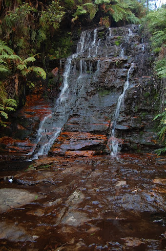
The lower portion of Witch’s Leap (May 2011)

Even though Witch’s Leap is not the largest or tallest waterfall, it might go down as the most creatively named waterfall in the Blue Mountains National Park. I don’t usually provide much history behind a name, but this one is intriguing enough. Apparently, to early explorers, it looked like there was a witch’s face in lower portion of the falls. I’m not sure I notice it.

If I have the positioning correct, there are two visible portions of Witch’s Leap, but they can’t be viewed at the same location. I don’t remember the exact location I viewed the upper portion of the waterfall, but it was along the cliff walk near Katoomba Falls. If you decide to hike down to the base (or the base of one of the drops!) of Katoomba Falls, you’ll see the lower portion of Witch’s Leap. You walk directly past it on your way to that viewpoint. There isn’t much water flowing over the falls, though it would likely increase after a heavy rain. Other waterfalls in the park were flowing more even though it hadn’t rained in the day or two before.

Directions:

  1. Head to Katoomba. You can actually walk to the falls from Katoomba, though it is easier to purchase an Explorer Bus pass that gets you to the falls. The falls are found at stops 10, 11, or 12.
  2. Find the trail on the left (west) side of Katoomba Falls. Along the way down this trail, you’ll pass the lower portion of Witch’s Leap

Accessibility: 10/10 (easy, from the cliff trail), 6/10 (moderate, to get to the lower portion)
Height: 20′ (lower portion)
Hike: 0.4 miles round-trip

The upper portion of Witch’s Leap

Where in the World is Witch’s Leap?

Unnamed Falls, Blue Mountains NP, New South Wales

A waterfall in the Blue Mountains National Park (May 2011)

I’m guessing that most people headed to Wentworth Falls aren’t going to intentionally try and find this waterfall, but if you’re on the Charles Darwin Walk, you might find this smaller waterfall. The walk is actually very beautiful. It was really enjoyable on this early May morning. There was some frost on the plants as I started.

The falls themselves are pretty close to Wentworth Falls. The trail starts in the town, and then ends at Wentworth Falls. Right before reaching the crest of Wentworth Falls, you’ll find this waterfall.

Directions:

  1. From the Wentworth Falls train platform, climb up the stairs and head left into the town.
  2. This got a little bit confusing.  You’ll see a number of shops in front of you.  Head down any of the streets to the right of you that run perpendicular to these shops.  You should end up at the main highway 32.
  3. From there, look for a sign indicating the trail that leads to Wentworth Falls.  It’s called the Charles Darwin Walk, and once you find it (near a children’s park), it’s a pretty easy and enjoyable walk.
  4. As you get near the falls, you do begin to descend toward the falls.  Follow the many different signs to see the different viewpoints available.
  5. Head back the way you came.  There’s another way to get back, but it led me more out of the way than I expected.  Overall, it’s about a 3 hour hike, and it’s about 3.5 miles, I think.

Accessibility: 7/10 (easy/moderate)
Height: 15′
Hike: 3.5 miles or so round-trip

Where in the World is the Blue Mountains Waterfall?

Leura Cascades, New South Wales

About 2 hours outside of Sydney (by train) is Blue Mountains National Park. It is nearby the towns of Katoomba and Leura. If you have the time, it is definitely worth it to visit the park.  In addition to it being stunningly beautiful, there are also a number of waterfalls. Many of them are very easily accessed, and the Blue Mountains Explorer Bus can help with this.

I decided to try and find the Leura Cascades and Bridal Veil Falls, and in the end, this was not that difficult to achieve. I think on the way there, I just walked to the start of the trail, though I didn’t exactly realized that it was leading to the falls and the cascades. I think I visited Bridal Veil Falls first, because I then remember hiking uphill and stumbling upon the Leura Cascades. Both are along the same creek.  It was rather dark at the time, so it was somewhat difficult to capture the falls.  Sunset was quickly approaching.  It was an easy hop back onto the bus, and then a short walk to my lodging for the night.

Directions:

  1. If in Katoomba, I would suggest taking the Blue Mountain ExplorerLink bus to stop 16 or 17. Both will lead you to the Leura Cascades and Bridal Veil Falls. If you start at 16, you can loop around to 17, and vice-versa.

Accessibility: 6/10 (moderate, there are some slippery parts here, though there are stairs, especially if you start at stop 17)
Height: ~45′
Hike: 0.6 miles round-trip

Leura Cascades in May 2011

Where in the World is Leura Cascades?

Gordon Falls, New South Wales

Gordon Falls in May 2011

If you have the chance to visit the Blue Mountains while in the Sydney area, I would suggest taking the Blue Mountains Explorer Bus for most of your explorations in the area. The bus stops at most of the interesting scenic sites in the park. You can essentially hit a number of different places all with the setup.

One of the stops that isn’t as busy is the stop leading to Gordon Falls, though that may be because I went later in the day. The hike is very short, and you get an interesting view of a tall, but narrow, falls. They aren’t nearly as impressive as Wentworth Falls or Katoomba Falls, but you should still check it out because it’s so easy to visit…and the scenery is stunning. The falls you see are likely to be highly dependent on recent rainfall.

Directions:

  1. You can access the falls from either Katoomba or Leura.  If you’re driving, Leura would be the better choice, as then it’s a straight drive south on Leura Mall to Gordon Rd.  You would then veer right on Lone Pine Ave to the parking area at the end.
  2. If you’re taking the Blue Mountain Explorer Bus, you’ll get off at Stop #18.  This will be helpful even if your driving, as you can look for the sign.
  3. From the parking area, follow the short trail to the falls.  I didn’t explore whether hiking further on the trail led to better views since I had limited time.

Accessibility: 9/10 (easy)
Height: ~660′
Hike: 0.1 miles or so round-trip

Where in the World is Gordon Falls?

Katoomba Falls, New South Wales

Katoomba Falls in May 2011

Of the many waterfalls in the Blue Mountains National Park, Katoomba Falls might just be the most impressive! At around 800′ tall, it’s really a truly spectacular view.

Katoomba Falls can be easily accessed by the Blue Mountains Explorer Bus. Look at the map to determine the stop. Once you get there, you can view the falls from numerous different vantage points. I believe there is one to the right of the falls, but it doesn’t necessary lead to the best view. If you head west, you’ll end up seeing the Katoomba Cascades, and then you’ll come out to the left of the falls. A trail leads to the base of the first drop, and if you zoom in on the picture, you might notice the very brave people standing at the base. There is a rope to prevent people from going too far, at least in theory. Nobody really seemed to heed the rope.

Continue down the trail on your left, and you’ll end up at another viewpoint of the falls that I liked the most. This one seemed to best reveal the true magnitude of the falls. While you’re further away, you realize that this is one tall waterfall. There are two major drops, and it seemed like the falls might just continue on a ways further “downstream.”

Directions:

  1. Head to Katoomba. You can actually walk to the falls from Katoomba, though it is easier to purchase an Explorer Bus pass that gets you to the falls. The falls are found at stops 10, 11, or 12.
  2. Explore around the area for your favorite vantage point. A trail on the left side of the falls is really fun, and I believe you pass by an interesting, but much smaller, second waterfall.

Accessibility: 10/10 (easy, from the viewpoint near stop 10), 6/10 (moderate, to get to the other viewpoints)
Height: ~800′
Hike: 0.2 miles or so round-trip

Where in the World is Katoomba Falls?

Wentworth Falls, New South Wales

Lower portion of Wentworth Falls (in May 2011)

Because of the transportation decisions I had made, I got to take the more roundabout method of getting to Wentworth Falls. If you have a car, it’s pretty easy. Just head to the parking area for the falls, and then you’ve got a short hike to the falls themselves.

If you decide to take the train from Sydney, like I did, then you have to figure out an alternative. I had stayed in Katoomba the night before, and since it was my first full night in Australia, I woke up very, very early. I finally was able to determine that a train was going from Katoomba to Wentworth Falls soon (about every hour), so I went to the train station, and headed to Wentworth Falls. After getting off at Wentworth Falls, I got myself confused.

The signs to the falls were clear, except there could be a few more. I started walking in the direction of the sign, but that seemed to lead to the highway. It turned out (finding this out later) that I was heading in the right direction. I finally found the Charles Darwin Walk, and from there it was a very enjoyable, but early, hike to the falls. Frost covered many of the plants in the area.

Once at the falls, I started exploring to find the best view. On the left side of the falls, you get pretty good views of the upper portion of the falls, but you don’t get to see the lower portion. The upper portion is impressive, but seeing the lower portion makes you realize just how large Wentworth Falls is. To see the lower portion better, cross the river above the crest of the falls, and then climb a ways to get to a viewpoint above the falls. The sun was very bright at that point, and I thought I wasn’t going to be able to get any good views, but I covered the camera, and the pictures weren’t nearly as washed out. At 614′, it’s impressive!

Directions:

  1. From the Wentworth Falls train platform, climb up the stairs and head left into the town.
  2. This got a little bit confusing.  You’ll see a number of shops in front of you.  Head down any of the streets to the right of you that run perpendicular to these shops.  You should end up at the main highway 32.
  3. From there, look for a sign indicating the trail that leads to Wentworth Falls.  It’s called the Charles Darwin Walk, and once you find it (near a children’s park), it’s a pretty easy and enjoyable walk.
  4. As you get near the falls, you do begin to descend toward the falls.  Follow the many different signs to see the different viewpoints available.
  5. Head back the way you came.  There’s another way to get back, but it led me more out of the way than I expected.  Overall, it’s about a 3 hour hike, and it’s 3.5 miles, I think.

Accessibility: 7/10 (easy/moderate)
Height: 614′
Hike: 3.5 miles round-trip

Upper portion of Wentworth Falls

Where in the World is Wentworth Falls?

Katoomba Cascades, New South Wales

The Katoomba Cascades aren’t the biggest attraction in the Blue Mountains National Park, but it’s still a pretty cascades nonetheless. It’s just upstream of Katoomba Falls, and the cascades are very easily accessed. If you want to play around in a waterfall, this might be the better option when compared to the more dangerous Katoomba Falls.

You can’t see the cascades from the road or any viewpoint right away, but just a short hike from the bus stop leads to these falls. I can’t remember if you had to rock-hop or cross a bridge to get over the creek. There were a number of people playing in the shallow water below the falls, though.

Directions:

  1.  Using the Blue Mountain bus, go to stop 10.
  2. From there, you will be face with two options.  Take the right path that leads into a wooded area.  From there it’s a very short hike to the falls.

Accessibility: 10/10 (easy)
Height: ~30′
Hike: 0.15 miles round-trip


Katoomba Cascades in May 2011

Where in the World is Katoomba Cascades?

Unnamed Falls, Blue Mountains NP, New South Wales

The likely ephemeral waterfall in May 2011

Obviously there are a number of much larger and more impressive waterfalls in the Blue Mountains of Australia, but if you’re visiting at the right time of year, I’d expect that you’ll be able to see this smaller waterfall just to the left of Katoomba Falls. It can really only be seen when you are standing at the Cliff View Lookout, which is most easily accessed at stop 9 on the Blue Mountain ExplorerLink Bus. From there, look to the left of Katoomba Falls (not the best view for the falls), and you might just see this smaller falls.

Directions:

  1. In Katoomba, take the Blue Mountain ExplorerLink bus to stop 9. Walk down the stairs to the Cliff View Lookout. You can also access this from stop 10.

Accessibility: 10/10 to the viewpoint (easy)
Height: Unsure (hundreds of feet)
Hike: 0.35 miles round-trip

Where in the World is Unnamed Falls?:

Bridal Veil Falls, New South Wales

Bridal Veil Falls in May 2011

After traveling over 9,000 miles, I wasn’t suffering jet-lag as much as some people might. I took the CityLink train from Sydney to Katoomba, which was an enjoyable two hour ride. After getting here, I went to check in at the lodge because I couldn’t carry around my bags anymore. I wasn’t sure what to do with myself after this, though.

I thought about visiting Wentworth Falls, but realized that I had not planned that out very well train-schedule-wise. I decided to head instead for the falls closer by. I bought a Blue Mountain Explorer bus pass, which is definitely handy, but missed the bus as it was passing by. I decided I must be crazy enough to keep going, looked at the map, and decided to head toward the Leura Cascades. It didn’t seem too far away, and it really wasn’t. Following the signs, I wandered through lush forests to finally arrive at this waterfall here. It’s at the Bridal Veil Lookout, and I’ve seen it referred to as Bridal Veil Falls. This is confusing as there is another waterfall nearby with the exact same name. This waterfall is the plunge below the Leura Cascades. It’s an impressive drop, though hard to photograph from the top.

Directions:

  1. If in Katoomba, I would suggest taking the Blue Mountain ExplorerLink bus to stop 16 or 17. Both will lead you to the Leura Cascades and Bridal Veil Falls. If you start at 16, you can loop around to 17, and vice-versa.

Accessibility: 6/10 (moderate, there are some slippery parts here, though there are stairs, especially if you start at stop 17)
Height: Unsure (hundreds of feet)
Hike: 0.6 miles or so round-trip

Where in the World is Bridal Veil Falls?