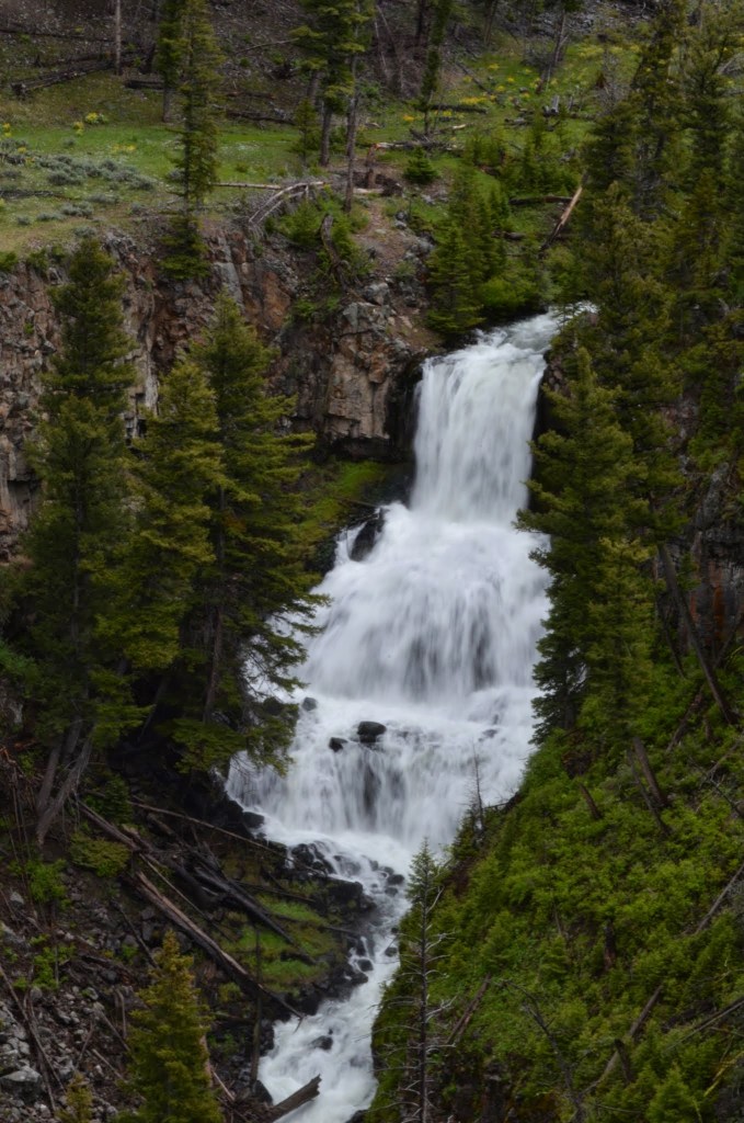
Rustic Falls, Wyoming

Rustic Falls in June 2014

There are so many beautiful waterfalls in Yellowstone National Park, in addition to all of the other amazing scenery and geological features. I’m ready to go back again and explore more! It’s been about 10 years since I’ve visited, so maybe next year is the right time to return.

Some of the waterfalls in the park are very widely known, mainly the namesake Lower Yellowstone Falls and Upper Yellowstone Falls. They’re relatively easy to visit, as are many of the others. None of them required a long hike that I can remember. A number of them are roadside waterfalls, and Rustic Falls is one of those roadside stops that make it so worth it to visit the park.

Rustic Falls is listed as being 47′ tall. That might be the top portion of the falls with some additional cascades below the falls. It’s a wider waterfall than some, so it seems like a bigger waterfall to me.

The best time to visit the park is in the summer months, at least for waterfalls and limited snow. Even when I visited in June 2014, it was rather cold and rainy, though the closer I got to Montana, the warmer it became.

Directions:

  1. There is a northern entrance to the park near the Montana/Wyoming border. The entrance is along US-89 and then heads into Mammoth. Mammoth is where you’ll find the Mammoth Hot Springs.
  2. To find Rustic Falls, you want to head south along US-89. About 5 miles south of Mammoth, you’ll find a parking area for the falls. If I remember correctly, there may be a sign but not much else. You’ll still have great views of the falls.

Accessibility: 10/10 (easy)
Height: 47′
Distance of Hike: roadside

Where in the World is Rustic Falls?
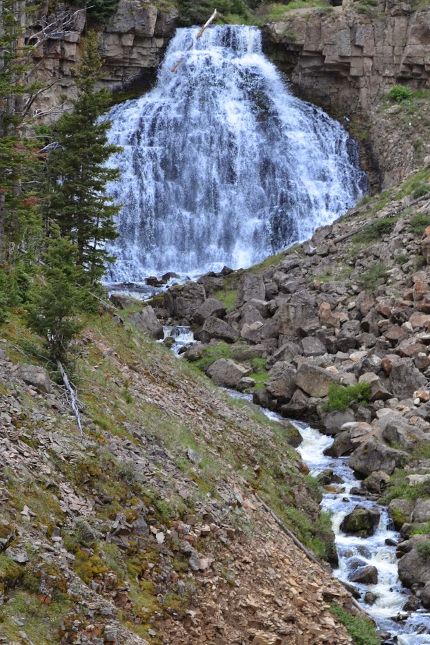
Undine Falls, Wyoming

Yellowstone National Park has a number of very impressive waterfalls within its boundaries. Most of them can be visited without much difficulty. Undine Falls is a roadside waterfall that requires minimal effort to view. Just pull off the road…I think there might be a designated pull-off/parking area, though many vehicles just pull off to the side of the road anyway to view wildlife. (There were damaging floods in 2022, so I’m assuming that the pull-off would still be there, though it may be damaged.)

Undine Falls in June 2014

There’s a loop that goes around…it could be described as two connected loops. Undine Falls is on the northern portion of the upper loop. It’s not that far from Mammoth Hot Springs. Wraith Falls is essentially right across the road. They’re separated by barely a mile in distance. Wraith Falls requires a hike, whereas Undine Falls doesn’t. I think this was the area where I saw a bear on a slope, and I only noticed because of the above mentioned cars that were pulled off to the side of the road!

Directions

  1. Mammoth Hot Springs and Fort Yellowstone are found along US-89. Those essentially represent the northern entrance to Yellowstone National Park.
  2. If you head east on Grand Loop Road, you’ll be headed toward Undine Falls.
  3. Undine Falls is about 4 miles east of the intersection of US-89 and Grand Loop Road. If you’re headed east, it will be on the left side of the road.

Accessibility: 10/10 (easy)
Height: 100′
Distance of Hike: roadside

Where in the World is Undine Falls?

Kepler Cascades, Wyoming

There are so many wonderful waterfalls in Yellowstone National Park. With the geysers, geothermal features, and wildlife, it’s understandable why it’s such an amazing place! I visited in June 2014, and while the roads were clear of snow, it was still pretty chilly. One of the days it rained constantly and I wasn’t going to waste my time, so I did everything in the chilly rain. I was soaked when I got back to my cabin.

Kepler Cascades in June 2014

Kepler Cascades is one of the less visited waterfalls. It’s rather close to Old Faithful and the lodges, so it’s an easy stop if you’re visiting Old Faithful, which you should! There’s no hike required to view the falls. They’ve set up a viewing area. So don’t miss the Kepler Cascades when you visit Yellowstone National Park.

Directions:

  1. As I mentioned, Kepler Cascades is near Old Faithful and the lodges. Old Faithful is off of US-191.
  2. Drive just a bit further south on US-191 from the Old Faithful Lodge and on your right, you’ll find a parking and viewing area for the Kepler Cascades and the Lone Star Trailhead. There isn’t any hike required.

Accessibility: 10/10 (easy)
Height: ~50′
Length of Hike: negligible

Where in the World is Kepler Cascades?

Lower Yellowstone Falls, Wyoming

DSC_1169

Lower Yellowstone Falls in June 2014

I visited Yellowstone National Park five years ago, and yet I’m just now getting to one of the major features of the park, Lower Yellowstone Falls. Upper and Lower Yellowstone Falls are stunningly beautiful, and they’re definitely worth seeking out if you’re in the park.

With Old Faithful and so many other geysers, Mammoth Hot Springs, and the wildlife, it can be difficult to choose what to do. And you should plan enough time to visit all of them. But you should also plan to visit a number of waterfalls, and if you only have time for a few, the falls on the Yellowstone River are probably the best to choose. The scenery around the falls is amazing.

The falls are very easy to get to and visit. They can be accessed just south of Canyon Village. From the North Rim Drive, Inspiration Point, Grandview Point and Lookout Point all give different views of the Lower Falls. From the South Rim Drive, Artists Point gives a view of the Lower Falls. As a waterfall fan, I believe I stopped at a number of these viewpoints since each stop is unique. Uncle Tom’s Trail is found on the South Rim, and that also leads down to a view of the falls. I did not do that, as I’m not a big fan of stairs/heights. No matter what, you’ll be able to find a wonderful view of the falls.

Directions:

  1. Canyon Village is found at the intersection of Norris Canyon Road and Grand Loop Road.
  2. From that intersection, head south on Grand Loop Road, drive approximately 2 miles and you’ll find the N Rim Drive and S Rim Drive. Choose which viewpoint you want to visit, and that will help decide whether you want the North Rim or South Rim.

Accessibility: 10/10 (easy)
Height: 308′
Length of Hike: variable, but often negligible

Where in the World is Lower Yellowstone Falls?

Pine Creek Falls, Montana

Pine Creek Falls Montana (5)

Pine Creek Falls in June 2014

When I visited Montana and Wyoming in 2014, I visited a number of Wyoming waterfalls in Yellowstone National Park. In Montana, I was able to visit two waterfalls on the way from Bozeman and back. The first, Ousel Falls, is outside of Big Sky. The second, Pine Creek Falls, is a bit more isolated and off the beaten path. (As the crow flies, these waterfalls are about 45 miles apart. In reality, the drive between the two is much longer.

I visited this one on the way back from Yellowstone. I exited Yellowstone from the north entrance, heading along US-89 toward Livingston. The roads and trails to the falls are not wildly far off of US-89, and the drive to the falls was stunningly beautiful. US-89 hugs the Yellowstone River for much of the drive. After veering off US-89 to get to the campground and trail head, there was some driving down some forest roads. I don’t remember them being particularly problematic, but it was four years ago.

I also don’t remember the hike to the falls being particularly difficult. It was in a mountainous area, so there was some elevation climb, I’m sure. I usually remember if the elevation climb is steeper, and this one doesn’t ring a bell. (The elevation change is listed at 390′ gain over 1.25 miles, so it is not wildly steep, but still will some uphill climb.) The trail head had a few other cars, with a few other people, including one larger family, hiking the trail. The hike to the falls was beautiful, though I tried to stay nearby others. (You should be aware of bears and another animals in the area.) Overall, it’s definitely a worthwhile hike to get a quick burst of Montana beauty a bit further from the busy Yellowstone trails.

Directions:

  1. I would take a look at a map of US-89 in Montana to get an idea of the best road to turn on to get to the falls. One option would be to turn onto Pine Creek Road, and head east on it.
  2. Turn right on MT-540, East River Road, and head south for a few miles.
  3. Turn left on Luccock Park Road, which is the forest road. Head east on this to the end of the road, which will be the start of the trail head and also where you’ll find the campground.

Accessibility: 7/10 (Easy/Moderate)
Height: 100′
Length of Hike: 2.5 miles round-trip

Where in the World is Pine Creek Falls?

Firehole Falls, Wyoming

There are many memorable waterfalls in Yellowstone National Park. Upper and Lower Yellowstone Falls are probably the main attractions, understandably so. Other falls, like Tower Falls and Gibbon Falls, might play second fiddle, but are still interesting stops. Firehole Falls is a nice waterfall, but probably one of those waterfalls you’d go searching for if you’re really into waterfalls (like me).

A few reasons do exist to view the falls. First, it’s easy to get to. While the road to the falls is one-way (so choose where you start carefully), it’s a short drive, and once you arrive at the falls, you’re there! There’s no hike involved. Second, you’ll probably be one of only a few people there. Some parts of Yellowstone are moderately to crazy busy, depending on the time of year. Firehole Falls is a quiet respite from the crowds. And honestly, I would argue anywhere in Yellowstone is worth the visit!!

Directions:

  1. From the intersection of US-89 and US-20/191/287, head south on US-20/89/191/287 (Grand Loop Road). (There are a lot of numbers for this one road!)
  2. After about 2000 feet or so, turn right onto Firehole Canyon Road. It’s one way, so you can only enter at this point.
  3. Drive a bit less than a mile along Firehole Canyon Road to the waterfall, which will be on your right.

Accessibility: 10/10 (easy)
Height: 40′
Length of Hike: roadside

Firehole Falls

Firehole Falls in June 2014

Where in the World is Firehole Falls?

Tower Falls, Wyoming

dsc_1208

Tower Falls in June 2014

Yellowstone National Park has some truly awesome, amazing waterfalls. Upper and Lower Yellowstone Falls are should be at the top of everyone’s list. But there are many other falls that are easy to visit, and Tower Falls just happens to be one of them.

So let’s start with the positives. Tower Falls is pretty easy to get to. There’s a short hike, and along the way you’re likely to a variety of wildlife. When you arrive at the viewpoint, you’ll be rewarded with a 132′ waterfall. It’s a beautiful waterfall surrounded by beautiful scenery.

So what are the “negatives”…it’s hard to use that term when referring to Yellowstone National Park..the negative is that the trail is currently shorter than it used to be. One used to be able to get to the base of the falls, where the view was more impressive. From the current end of the trail, you’re rather high above the falls, and the trees block off the lowest portion of the falls. That shouldn’t stop you from visiting the falls. The hike is short enough that it doesn’t take a significant amount of time out of your day.

Directions:

  1. From the Hot Springs Visitors Center/Entrance, head east along the road toward Tower-Roosevelt. (You could also head west from Cooke City toward Tower-Roosevelt.) Along the way you’ll pass Undine Falls and Wraith Falls.
  2. At the junction in Tower-Roosevelt, head south toward Canyon Village. (This road is only open from approximately mid-May to mid-October.)
  3. After two or so miles past the junction, you’ll come to the parking area for Tower Falls (which would be on your left if heading south). The parking area was rather popular, so if you want to see the falls, be patient.
  4. From the parking area, follow the trail to the falls.

Accessibility: 7/10 (easy/moderate)
Length of Hike: 0.9 mile round-trip
Height: 132′

Where in the World is Tower Falls?

Wraith Falls, Wyoming

Wraith Falls in mid-July 2015

In Yellowstone National Park, the very well known Lower and Upper Yellowstone Falls can be found. In the park, though, are a number of other waterfalls. While some of the others are widely visited, a few are quieter, which might be nice if you’re looking for something a bit less busy.

Wraith Falls might be a good choice for the “less busy” in Yellowstone. On the hike to the falls, I only passed 2 or 3 other groups of people. I distinctly remember being slightly more worried about bears in the area since this area wasn’t as traversed. I didn’t see any bears or wildlife here, though just down the road, I do remember seeing a bear along a hillside.

The hike to Wraith Falls is fairly straightforward. It’s about 1/2 a mile to the falls from the parking area, which has enough space for 5 or 6 cars. I didn’t have any issue finding parking. The hike goes pretty quickly, and you’ll arrive at the falls in 15 minutes or so. You won’t be able to get particularly close to the falls because of the way the trail is set up. As you might be able to tell from the picture, there is a lot of debris in the way of the falls, preventing you from getting much closer. It’s still an interesting waterfall, looking much like a washboard.

Directions:

  1. Wraith Falls is found along the northern portion of the Grand Loop Road between US-89 and US-212. (I’m not 100% sure what roads are open during what times of the year, so check before you decide to visit if planning for Fall-Spring.)
  2. From Mammoth Hot Springs, head east along the Grand Loop Road.  The pullout for the falls is about 0.5 miles east of the Lava Creek Picnic Area. I don’t remember if the parking area was signed, but it was relatively easy to find.
  3. From the parking area, follow the short trail to the falls. There is a small portion of it that is uphill, but it isn’t difficult.

Accessiblity: 9/10 (easy)
Length of Hike: 1.0 mile round trip
Height: 79′

Where in the World is Wraith Falls?

Gibbon Falls, Wyoming

Sometimes the order I post is based on random chance, but when I take a trip, I will usually post the first waterfall I see in that state. Yesterday, I posted about the first Montana waterfall, Ousel Falls. Today, the first waterfall I saw in Wyoming…Gibbon Falls.

Gibbon Falls is a nice waterfall, though it is not the most interesting or photogenic in Yellowstone National Park. That crown is held by the Lower Falls of the Yellowstone, which is a wildly, wildly photogenic waterfall, but I’ll save that for a different post. But Yellowstone National Park is full of amazing geysers, waterfalls, chances to view wildlife, and it’s all pretty easy to see because of the way the road system was set up 130 years ago! So as you’re driving along, you’ll see an area to pull off for Gibbon Falls. There are a number of different places to view the falls. I found that the best viewpoint was actually in between the two unofficial viewpoints.

Gibbon Falls is about 84′ tall, and it’s “claim to fame” is that it’s at the edge of the caldera formed by the volcanic explosion 640,000 years ago. This caldera has undergone some erosion due to glaciation, and is extremely large, so it is nowhere near as noticeable as Crater Lake’s caldera. It’s amazing to me to think that you’re standing inside a massive volcano that is still active!

Directions:
There are five entrances to the park, so you choose which one works best for you. The entrance closest to Gibbon Falls is likely the West Entrance (near West Yellowstone), which as I mentioned before, was the “easier” entrance compared to the North Entrance. The falls are found halfway between Madison and Norris, and are clearly marked on the park map, and there is very good signage. It’s a worthwhile stop.

Accessibility: 10/10 (easy, wheelchair accessible, I think)
Height: 84′
Length of Hike: Roadside

Gibbon Falls in mid-June 2014

Where in the World is Gibbon Falls?

Ousel Falls, Montana

These past few days, I’ve been visiting Yellowstone National Park, which is mostly in Wyoming. I flew into Bozeman, Montana, though, and decided to see if I could find any waterfalls in Montana on my way to the park. I found two easy-to-visit waterfalls, one on the way there, and one on the way back.

Ousel Falls was the first of the falls I visited along my journey, and it was an easy visit. It is just a few miles off of US-191 (which I felt was the much easier way to access Yellowstone from Bozeman). When you turn to head to Big Sky, you’ll pass through a surprisingly nice residential and recreation area. (It was more “built up” than I was expecting.)

After arriving at the trailhead, it’s a 3/4 mile hike to the falls. It isn’t extremely difficult, though it isn’t flat, consistently uphill, or consistently downhill. It’s more of a “roller coaster” hike ranking on the easier side of moderate. There are two views of the falls. One of the views shows the upper “drop” more clearly. The view at the base of the falls reveals much of the beautiful rock surrounding the falls. Either of these produce great photos, and there’s a picnic area at the base. This is definitely a worthwhile detour while heading to Yellowstone, and you’ll even find some nice restaurants in the Big Sky resort area.

(And an ousel is a kind of bird. A waterfall in Colorado, Ouzel Falls, is also named after the bird, just with a different spelling.)

Directions:

  1. Head south along US-191 from Bozeman (or from Belgrade, which is nearer the airport).
  2. After 40 miles or so, turn right onto MT-64 and head toward Big Sky. You’ll drive for two or so miles through residential areas, restaurants, shops, and a golf course
  3. Then turn left (more like veer left) onto Ousel Falls Road. Drive until you reach the Ousel Falls Trailhead, which will be on your left. There’s a big sign!
  4. Start the hike to the falls!

Accessibility: 7/10 (easy/moderate)
Height: 55′
Length of Hike: 1.6 miles round-trip

Ousel Falls in June 2014

Ousel Falls in June 2014

Where in the World is Ousel Falls?