Bridal Veil Falls, Alaska

Bridal Veil Falls in August 2014

My husband asked me the other day if I had been to Bridal Veil Falls, and my response was “Which one?”! It seems to be one of the most common waterfall names that I’ve run into (at least in English). After a quick check, I’ve visited 14 Bridal Veil Falls in 3 different countries. And as of right now, this is the last Bridal Veil Falls I have to write about until I visit another one.

This Bridal Veil Falls comprises what I’ll call a set of three falls you can very easily see if you’re approaching Valdez, Alaska. Unless you’re visiting Valdez, that may be the first big step. And you may visit Valdez on an Alaskan cruise and unless you head onto Alaska state road 4, you won’t see these falls. Two of the falls are named: Bridal Veil and Horsetail Falls, and then there’s another one I’ve called Keystone Canyon Falls. They’re all within a short distance of each other.

And if you’re on the road, drive safely! You won’t have to search hard for these falls, though. You’re surrounded by some amazing cliffs/mountains on both sides of the road, and these are flowing down those cliffs! You will just need to find some place to pull off safely, which if I remember correctly, also wasn’t difficult. From some online maps, I calculated the height of the falls to be about 400′. The city of Valdez says it’s 600′, which could also be possible. Once a waterfall gets this tall, there are some drops that can be difficult to see. It’s definitely worth it to see these falls if you’re in Valdez for some reason!

Directions:

  1. There isn’t any other way to enter Valdez via road than on Alaska Route 4. From Anchorage, you’d follow AK-1 for a really long time to the junction of AK-4.
  2. Turn right and head south on AK-4, and then after an hour or so, you’ll enter Keystone Canyon. It’s clearly signed. It’s hard to miss the different waterfalls.

Accessibility: 10/10 (easy)
Length of Hike: roadside
Height: 400-600′ (it’s tall!)

Where in the World is Bridal Veil Falls?
Fairy Falls, New Zealand

DSC_2299

Fairy Falls in May 2011

It ends up that there are two Fairy Falls in New Zealand: Fairy Falls on the North Island outside of Auckland, and a Fairy Falls on the South Island in Milford Sound. This is about the South Island version of Fairy Falls.

Milford Sound is one of my favorite places on the planet. There’s a stunning beauty to the location. And for a waterfall lover, there are no lack of waterfalls in the sound. Bridal Veil Falls is right next to Fairy Falls, and then you can find Bowen FallsStirling FallsPalisade Falls, and other Milford Sound Waterfalls in the sound itself. The best way to view all of the falls is to take a cruise (or kayak if that sounds exciting). I took a cruise later in the day, and it was perfect. In addition to waterfalls, I saw a significant amount of marine wildlife, including seals and dolphins/porpoises. It was definitely a wonderful visit, and I’m ready to go back again!

Directions:

  1. From Te Anau, head north on NZ-94 to its very end at Milford Sound. (From mid-May to October, you may want to check to make sure that the road is open to Milford Sound…It can close randomly, or snow chains may also be required.)
  2. At Milford Sound, park, head to the cruise area and board your cruise.

Accessibility: 10/10 (easy)
Height: 100′
Length of Hike: not applicable

Where in the World is Fairy Falls?

Keystone Canyon Falls, Alaska

keystone

Keystone Canyon Falls in August 2014

Keystone Canyon is one of those places that is hard to describe. On the way in to Valdez, I had been driving for about an hour and a half. (It’s about 5 hours from Anchorage via road.) Even if I had been driving for longer, I think I would still have had my breath taken away as I entered Keystone Canyon. It was drizzling a bit, giving the canyon a special atmosphere. The road winds through the canyon, at times crossing over the Lowe River. Cliffs climb above you on both sides of the road.

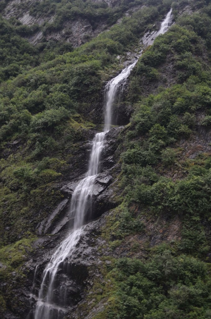
And then the waterfalls start appearing. Bridal Veil and Horsetail Falls are the two named waterfalls. As I’m driving along, though, I see another waterfall. I don’t know if this one has a designated name, and I wasn’t sure what the name of the creek was, therefore it’s Keystone Canyon Falls to me.

The mountains above the gorge climb about 5500′ feet in the matter of about 4 miles. So while you’re probably seeing about 100′ of waterfall in this picture, there’s likely more waterfall hidden above.

I often mention whether you should go out of your way to see a waterfall…In this case, it’s taken to extremes. I was headed to Valdez to go on a day-long glacier/wildlife cruise. As I mentioned, the drive from Anchorage to Valdez is about five hours, and there are long stretches of beautiful nothingness. You could fly, but then you’ll miss these waterfalls. On the way, you’ll get some great views of Wrangell-St. Elias National Park, and a “short” detour from the road to Valdez will lead to Liberty Falls. In addition to Bridal Veil Falls and Horsetail Falls, there’s also Crooked Creek Falls in Valdez. With all of the additional beautiful, it’s a good reason to drive, but you’ve got to set time aside just for this.

Directions:

  1. There isn’t any other way to enter Valdez via road than on Alaska Route 4. From Anchorage, you’d follow AK-1 for a really long time to the junction of AK-4.
  2. Turn right and head south on AK-4, and then after an hour or so, you’ll enter Keystone Canyon. It’s clearly signed. It’s hard to miss the different waterfalls.

Accessibility: 10/10
Length of Hike: roadside
Height: ~100′ (could be more or less, not the greatest judge of height)

Where in the World is Keystone Canyon Falls?

Spearfish Falls, South Dakota

DSC_0717

Spearfish Falls in May 2016

I’ve been wanting to visit Spearfish Canyon in South Dakota for a number of years now, but for some reason have never taken the time to visit. (Flying into Rapid City is generally more expensive than some other places, which may play a factor in my decisions.) I made the decision to visit this year, though, and have now had the pleasure of visiting the Black Hills and Spearfish Canyon.

South Dakota has a number of waterfalls (compared to North Dakota, which apparently only has ONE). There are three clearly advertised waterfalls in Spearfish Canyon: Spearfish Falls, Roughlock Falls, and Bridal Veil Falls. I’ve come to believe that there could be more than expected. (Check out Annie Creek Falls and the Devil’s Bathtub for at least two other waterfalls that aren’t as well advertised.) All three of the advertised waterfalls are easy to visit.

Spearfish Falls is found near the Latchstring Restaurant, which I would suggest stopping at to eat. (Support businesses that support waterfalls!) They have changed the path to the falls, and at first glance, it appeared that the trail was still closed. After eating, I asked someone at the restaurant about the falls, and she said that it was fine to walk to the falls even with the sign up. With that blessing, I went to see Spearfish Falls.

From the restaurant parking area, you head to the right. Cross the stream that turns into Spearfish Falls. Keep along the trail heading toward a house, but then veer right down a set of stairs. These stairs will turn into metal stairs and then a metal bridge crosses over another river. After crossing that river, the trail veers slightly to the left to avoid going on private property. From there, just follow the trail downhill. It’s pretty difficult to miss the falls! You’ll be rewarded with some pretty spectacular views.

Directions:

  1. In Spearfish, follow the signs for Spearfish Canyon. This will be US-14 ALT. Continue along this curving road until you reach an intersection where you’ll find the Latchstring Restaurant and Spearfish Lodge.
  2. Park at the Latchstring Restaurant, and then follow the directions given above. (You can also access this from the opposite direction, as I did, since I stayed in Lead.)

Accessibility: 8/10 (stairs, and a bit steep)
Height: 47′
Hike: 0.5 miles round-trip (at the most), seemed MUCH shorter

Where in the World is Spearfish Falls?

Morgan’s Steep Falls, Tennessee

Morgan’s Steep Falls in January 2016

I decided to take a trip to northern Alabama to see waterfalls, and ended up in Tennessee in the process. One of the first falls I tried to find was called Falls Mill Falls, and as I pulled up, I found out that it is closed for part of the winter. I then headed off to Sewanee, as I had a reservation at the Sewanee Inn, which is a very nice place to decide to stay. I was tired, so I ended up napping…and I never really thought I should check to see if there are any waterfalls in the area!

The next morning, as I was looking in my book of Tennessee waterfalls, I then discovered that there were a few waterfalls within 1 mile of my location! I could have been exploring those the day before! I still decided to check out one of the falls in the area.

There are at least three falls within a short distance of each other in Sewanee. The one you see here is Morgan’s Steep Falls, which is very easy to observe. The other two are Proctor Falls and Bridal Veil Falls, which I didn’t visit because they required longer hikes (and I hadn’t eaten yet). Each of those falls are found by hiking in opposite directions from Morgan’s Steep Falls.

Morgan’s Steep Falls isn’t the tallest or maybe even the prettiest waterfall, but because it’s so easy to get to, I would recommend stopping. From the (what I think was) a gravel parking area, it was a short 0.1 mile hike down some steps to see Morgan’s Steep Falls. Getting a good view of the falls did require a little bit of maneuvering, but even younger kids should be able to handle this falls. And as a side note, if you don’t like this waterfall, there are many other waterfalls in the area! Check those ones out too!

Directions:

  1. From US-41A, turn onto University Avenue (which forms a loop that connects back into US-41A).
  2. Drive along University Avenue to South Carolina Avenue.
  3. Turn onto South Caroline Avenue. Drive along South Carolina Avenue to the junction with Laurel Drive.
  4. You can really take either direction, as another loop is formed. If you take a left along Laurel Drive (more like veering left), you’ll end up circling back onto South Carolina Avenue later.
  5. The parking area for the falls is found at the end of this loop (or at least what I think was the parking area). It was a gravel area. (Make sure not to park on any private residences.)
  6. From there, go back to the trailhead. There is a sign for Bridal Veil Falls, but you want to take the stairs down to the other trail. Keep going along that path, and you will shortly arrive at Morgan’s Steep Falls.

Accessibility: 8/10 (stairs and a bit of maneuvering)
Length of Hike: 0.2 miles round-trip
Height: ~10′

Where in the World is Morgan’s Steep Falls?

Bridal Veil Falls, Utah

Bridal Veil Falls in early May 2013

I was looking at some of my previous posts about waterfalls near Salt Lake City, and realized that Bridal Veil Falls seems to be one of the more unique waterfalls in the region, beside the fact that it’s one of the tallest. Most of the other waterfalls I visited in the region required uphill hikes.

Bridal Veil Falls, on the other hand, is one of the few roadside waterfalls near Salt Lake City. Coupled with the fact that it’s 607′ tall, it’s one of the busiest waterfalls you could visit in the area. And yet I’m not sure it was my favorite. I found it to be a beautiful waterfall, and yet it’s not as intimate as some of the other waterfalls in the region. If I remember a correctly, there were ways to get closer to the falls, though I decided against that. (It may not even be allowed…I can’t remember.) There is a paved trail to the base of the falls with some fish in the pond there.

Directions:

  1. The falls is found directly off of US-189. The easiest way to get to US-189 is to probably take exit 272 on I-15.
  2. After exiting, head east on UT-52.  Drive until UT-52 merges with US-189.
  3. Head north along US-189 until you get to the exit for Bridal Veil Falls. It’s only accessible heading north. There is no exit heading south, so you will have to find another exit and loop around.

Accessibility: 10/10 (easy)
Distance of Hike: 0.1 mile round trip to base of falls (paved)
Height: 607′

Where in the World is Bridal Veil Falls?

Rocky Mouth Falls, Utah

Rocky Mouth Falls in early May 2013

For a number of the waterfalls along the Wasatch Range in and near the Salt Lake City metropolitan area, it felt that I was often climbing consistently uphill (and then downhill). There were exceptions, such as Hidden Falls and Bridal Veil Falls, but I definitely got a workout in over the three or four days that I visited waterfalls in the area.

Rocky Mouth Falls seemed to be the easiest of the waterfalls to visit that still required some uphill climbing. It’s an approximate 200′ elevation gain, though this happens over a relatively short 1/4 of a mile. This means there is definitely some steeper portion, though because it’s over with so quickly (compared to some of the other falls in the area), I didn’t really mind.

Getting to the trail isn’t difficult, but it is a bit odd. You start of at a designated parking area, and then walk along sidewalks into a residential area to the start of the trail. (As I’ve seen mentioned elsewhere, park in the designated area, and then be respectful as you walk through the area. It would be sad if use to this trail were ever lost.) After hiking that 1/4 mile, you’ll end up at the falls. I can’t seem to obtain an official height of the falls, and I’m really bad at judging height, but it’s tall enough to make it worth your while. I’m guessing that in the depths of summer, this might reduce to a trickle, so choose your visit appropriately.

Directions:

  1. It seems the easiest way to find this waterfall is to type this in on Google Maps in your phone or on your GPS. The trailhead is found near 11248 S. Wasatch Boulevard, which runs adjacent to the mountain range. It’s directly across from an LDS Chapel.
  2. From the parking area, follow the signs into the residential area. Keep following the signs to the start of the trail, which I remember was pretty easy to find.
  3. Start your journey along the trail to the falls!

Accessibility: 6/10 (moderate)
Height: 70′
Length of Hike: 1 mile round-trip

Where in the World is Rocky Mouth Falls?

Bridalveil Falls, California

One of the most stunning waterfalls in Yosemite National Park is Bridalveil Falls. While it’s only about 1/4 the height of Yosemite Falls (Bridalveil Falls clocks in at 620′ tall), that’s still pretty darn tall. You may notice a few other waterfalls before this one, but this is likely to be the first prominent waterfall you see as you enter the park.

The attribute Bridalveil Falls shares with Yosemite Falls is that there are so many different places to view the falls. With so many options, you may get the feeling that you’re seeing a completely different waterfall (though you’re not). As you follow the loop drive, there is a parking area very close to the falls. It’s a short walk along a paved trail to the base. In mid-May, the waterfall was thundering, and the spray made it almost impossible to photograph at the base, though it did guarantee you would get soaked in a very short amount of time. I was able to get some great shots at the start and along the trail where there wasn’t so much spray.

As you’re looping around the main road in the valley, you’ll notice Bridalveil Falls again, and you get that totally different view of the falls. The clouds may be low enough to shroud the cliff tops. The height of the falls might become a little bit lost (which, after a certain height, is tricky to gauge), but you will get a fantastic view of the much bigger picture that is Yosemite National Park.

Directions:

  1. Head toward Yosemite National Park. CA-140 into the park is usually the best bet for being open, though you can also enter via CA-120 or CA-41 at certain times of the year.
  2. If you want to park at the Bridalveil parking lot, you will turn onto CA-41 (Wawona Road) for a VERY SHORT distance to the parking area, which will be on the left. It’s a short hike to the falls.
  3. If you want to view the falls without stopping at the parking lot, follow the loop road to the Northside Drive (the northern portion of the road).

Accessibility: 10/10 (easy, don’t remember if it was uphill on the trail?)
Height: 620′
Length of Hike: 0.5 miles round-trip (though can be viewed from other spots)

Bridal Veil Falls in mid-May 2011

Where in the World is Bridalveil Falls?

Bridal Veil Falls, New Zealand

Bridal Veil Falls in May 2011

The North Island of New Zealand has a number of really great waterfalls. Wairere Falls and Marokopa Falls are impressive, and Bridal Veil Falls is another to add to the list.

At 180′ tall, Bridal Veil Falls has many things going for it. In addition to its height, it’s also surrounded by lush greenery. You also have a number of different options for viewing the falls. There’s not really a great view at the base, but as you start walking down the trail (which I think has stairs), you’ll start getting a better view. The picture here is from a third to half way down the trail. You’ll also get a great view from the base, and a bridge leads over the river. The waterfall was relatively powerful, so you’ll experience a lot of spray at the base.

Directions:

  1. From NZ-39 at Whatawhata, head west along NZ-23 for just over 26 kilometers.
  2. Turn left onto Te Mata Road and drive for about 7 km.
  3. Take a left turn to continue on Te Mata Road for 2.5 km more.
  4. Take a slight left onto Kawhia Road and drive for 3.5 km. You’ll see a sign for Bridal Veil Falls and a parking area.

Accessibility: 7/10 (easy/moderate, some stairs)
Height: 180′
Length of Hike: 0.8 miles round-trip

Where in the World is Bridal Veil Falls?

Milford Sound Waterfalls, New Zealand

One of the waterfalls in Milford Sound (May 2011)

Up until this point, I haven’t listed these waterfalls on any list, and I’m not sure why. When you visit Milford Sound, which you should do sometime in your life, you should take a 2 hour cruise through the sound. You’ll see wildlife, stunning views, and a significant number of waterfalls. Many of them show up only after it rains, while others are more consistent. You can check out the ones that have been clearly named, such as Bowen, Bridal Veil, Fairy, Palisade, and Stirling Falls. And yet, there are a number of other waterfalls that seem to last longer that haven’t been named, or if they have been named, there names haven’t been advertised very well.

So I’ve decided to include them, since they are in such a beautiful place, and are equally as scenic as some of the named falls. There’s not a whole lot of description required. I’m a really bad judge of height, but each of these is in the hundreds of feet tall! If you take the cruise, you’ll see eight or nine falls during sunny periods, and I’ve heard it increases even more so while raining. It’s a reason to take a cruise while raining!

Directions:

  1. From Te Anau, head north on NZ-94 to its very end at Milford Sound.  (From mid-May to October, you may want to check to make sure that the road is open to Milford Sound…It can close randomly, or snow chains may also be required.)
  2. At Milford Sound, park, head to the cruise area and board your cruise.

Accessibility: 10/10 (easy)
Height: ~100-200′
Length of Hike: not applicable

Another ephemeral waterfall

Another one!

Where in the World are the Waterfalls of Milford Sound?