La Mina Falls, Puerto Rico

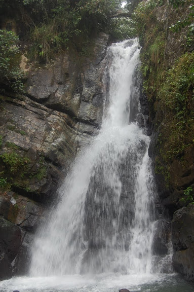
La Mina Falls in March 2010

Note: It seems the road to La Mina Falls might not be open currently (as of July 2018) due to the 2017 hurricanes. Once more info is available, I’ll try to update this…

It’s been a rather long time since I’ve posted a Puerto Rico waterfall, so I’m going to have to dig deep into the memory bank for this waterfall. I’m going to start by saying that Puerto Rico is one of those intriguing places that you should visit if you have the chance. If you live in the US, there’s no passport needed. It’s a unique mix of American, Spanish, and Caribbean, and I wasn’t always sure how to process what I was experiencing. One of the most enjoyable experiences on the island was visiting El Yunque, the spectacular rain forest on the eastern side of the island. (For the exact opposite experience, consider visiting the Guanica Dry Forest on the western side of the island).

El Yunque probably has more waterfalls than are advertised, though I’m guessing many of them might be hidden. La Coca Falls is found directly off the road, and is therefore very easy to visit. Juan Diego Falls is near the road, but since it is hidden from view, I found it to be the most enjoyable since I was the only one there. La Mina Falls is the furthest along the main road snaking through the rain forest, and requires the most hiking.

The hike to the falls starts at a parking area, and begins to head downhill. My father and I wore rain ponchos, which were useful for keeping us dry, but also had a tendency to make us feel sticky because of the high humidity. The 0.7 mile hike (one-way) was rather enjoyable, though you are climbing almost completely uphill on the way back.  It’s not extremely strenuous, though. The falls are very busy, though, as there will likely be people swimming in the pool below the falls. For peace and quiet, your best bet is probably early in the morning.

Directions:

  1. Head into El Yunque National Forest on Rte 191 (which is not very obvious from Rte 3).
  2. At km 12.2, you’ll find the Palo Colorado Ranger Station. The trail starts at this ranger station.

Accessibility: 6/10 (moderate)
Height: 35′
Length of Hike: 1.4 miles round-trip
(For a number of other suggestions on what to do in Puerto Rico, check out http://www.puertoricodaytrips.com/)

Where in the World is La Mina Falls?

La Coca Falls, Puerto Rico

La Coca Falls in El Yunque National Forest (March 2010)

Of the major waterfalls in El Yunque National Forest, La Coca Falls is by far the easiest to visit. The falls are right off the road and are the first waterfall as you drive up Rte 191.

La Coca Falls is probably best described as a slide falls. The water slides down a 60′ rock face, after which the creek narrows down significantly. It’s a very pretty waterfall, and the tropical rain forest surrounding it is just stunning. If you want to see a waterfall on Puerto Rico, this is your best bet, especially if you’re not interesting in hiking up and down hills. If you’re interested in hiking to a waterfall in El Yunque, check out La Mina Falls or the wonderfully hidden Juan Diego Falls. All three can be very easily visited in a couple of hours time.

Directions:

  1. Head into El Yunque National Forest on Rte 191 (which is not very obvious from Rte 3).
  2. La Coca Falls will be on the right side as you’re heading down Rte 191. It’s extremely obvious, and there is parking both before and after the falls.

Accessibility: 10/10 (easy, roadside)
Height: 85′
Length of Hike: not applicable

Where in the World is La Coca Falls?

Juan Diego Falls, Puerto Rico

Juan Diego Falls in March 2010

Sometimes, those things that aren’t advertised are the best. When you visit El Yunque National Forest in Puerto Rico, you’ll definitely know about La Mina Falls and La Coca Falls. They’re very clearly marked on the maps, and La Coca Falls is almost impossible to miss. On the other hand, somebody made the executive decision to NOT include Juan Diego Falls on that map…and waterfall lovers are better off for that :).

I found out about Juan Diego Falls from a blog/website, Puerto Rico Day Trips, an invaluable resource for anyone visiting Puerto Rico. From their description, I thought that getting to the falls would be complicated or difficult…and it sort of was, but not as hard as I had EXPECTED. Around km 9.5 along Rte. 191, you’ll come along a few “parking areas” along the side of the road. They’re not very big. There, you may notice a sign about Juan Diego. This is not the area of interest. Head about 25 feet to your left to a larger, wider “waterfall”, though this is not Juan Diego Falls.

On the right side of this, you’ll see a trail. Start heading up that trail. In a very short distance, you’ll come to the lower part of Juan Diego Falls, which is about 15 feet high. From there, you’ll be able to see the much larger upper part just a short distance away.  I noticed there was a worn path leading up the RIGHT side of the waterfall. It seems pretty steep, but it’s not too bad. It is slippery, though, so wear appropriate shoes. From there, you’ll have to do a little bit of leg work to get closer to your destination. After you’ve gone UP a ways, pay attention for the path that leads DOWN to the falls. It’s not very obvious, but if you look, you’ll find it. It’s not really a dangerous path, but be careful. With some effort, you’ll end up at Juan Diego Falls, a truly beautiful waterfall that is surprisingly secluded.

Directions:

  1. Head into El Yunque National Forest on Rte 191 (which is not very obvious from Rte 3).
  2. At about km 9.5, you’ll find turnoffs on the side of the road. From there, you’ll have to walk along the road a short distance to get to the trail described above.

Accessibility: 4/10 (moderate/strenuous)
Height: 25′
Length of Hike: 0.1 miles round-trip

Where in the World is Juan Diego Falls?

Merriman Falls, Washington

Merriman Falls in April 2008

There are at least three interesting waterfalls along South Shore Road in Olympic National Park: Bunch Falls, Merriman Falls, and Gatton Creek Falls (I think). I only fleetingly saw Gatton Creek Falls, so I can’t really say how it compared. Merriman Falls is the less photogenic of the remaining two, as it seems to be blocked by a lot of trees and other things. I thought it was maybe my picture, but then looking online, I realized that others also had not so great pictures of the falls. The one picture I saw really didn’t even have a clear view of the falls.

Nonetheless, the falls are found in an extremely beautiful area. Olympic National Park is one of my favorite national parks, and it has to do with the amazingly lushness of the temperate rain forest. This is one of the national parks I definitely want to visit again, and there are many other waterfalls in the park. A drive down South Shore Road is still worthwhile.

Directions:
1) From US-101, turn onto South Shore Road.
2) Continue on South Shore Road for a ways and you will pass other waterfalls before coming to Merriman Falls. I would just keep paying attention to the right side of the road, as this is where all of the interesting falls are. You’ll just have to stop on the road somewhere (possibly try to pull off), as there are no parking lots near the waterfalls.
3) You can either turn around at the bridge crossing the Elwha River, or continue onto North Shore Road, which is just as pretty.

Accessibility: 10/10 (roadside)

Where in the World is Merriman Falls?: map