Shannon Falls, British Columbia

Shannon Falls in August 2010

Shannon Falls just goes to show how deceiving waterfalls can be. Looking at pictures of the falls, it doesn’t look like an extremely tall waterfall, and yet Shannon Falls is actually one of the tallest waterfalls in British Columbia. At approximately 820′ tall, it’s a wildly impressive waterfall. Only when you’re standing near it do you begin to realize how small you are compared to this falls.

It’s a complex waterfall, and because of that, it can be somewhat difficult to photograph the whole falls. That is what likely makes it seem “shorter.” The lower portion of the falls is completely lost from view in the picture to the right. To get a better view of the lower portion of the falls, you sacrifice views of the upper portion. There are multiple different places to view the falls. A number of paths form what seemed like a loop that leads away from the falls and then comes back around near the base. The base of the falls allows for some exploring. Wedding photography was taking place near the falls when I visited, and I can’t deny that it was a really spectacular place to visit.

Directions:

  1. I want to say that this is a pretty hard waterfall to miss, though you might only be able to see it from BC-99 at certain angles.  That doesn’t change the fact that it is found right off of BC-99, approximately 58 km from Vancouver.  If you’re headed to Whistler, you’ll be passing by!  Heading north, the parking area for the falls will be on the right.  There is a $1 entrance fee for 1 hour (if I remember correctly), which was more than enough time to visit the falls.

Accessibility: 10/10 (easy)
Height: ~820′
Length of Hike: 0.4 miles round-trip (to viewpoint)

Where in the World is Shannon Falls?
Alexander Falls, British Columbia

Alexander Falls in August 2010

The trip to Alexander Falls could be described as interesting, to say the least. Alexander Falls is found very close to Whistler Olympic Park, where a portion of the Winter Olympics were held in 2010. Since the Olympics were coming, some new roads were built in the area, and some old ones were redirected. This is one way to create some confusion.

The old way used to lead one down a forest service road that was unpaved, but still could be driven on. The confusing part was when that road forked unexpectedly. I think part of the road was blocked off, and the only option was to go on a road that was very newly paved. This can be very odd at first, and I wondered if this was some private road. Considering it was the only option, though, I continued on the paved road. Luckily, I discovered that the falls were a very short distance from this intersection.

It also revealed there is a MUCH easier way to see the falls now. The Callaghan Valley Access Road (not forest service road) is a newly paved road that leads you directly to the falls, and on further to the Olympic park, which you can still visit. Once at the falls, you don’t even have to walk to the falls. Just get out of your car, and they’re essentially in front of you. When I visited in August 2010, I had the whole place to myself, not that there was a whole lot there. The waterfall is very scenic, and I was relieved to know that I wasn’t lost in the wilderness.

Directions:

  1. Callaghan Valley Access Road doesn’t really show up on all GPS/Google Maps yet. From the last stoplight in Whistler, head south on BC-99 for about 6.5 km.
  2. On your right, you’ll find the road that should indicate the Whistler Olympic Park. Turn right here. Head down the road for a few kilometers until you reach the Alexander Falls park, which will be on your left. If you’ve gone to far, you’ll have passed the bridge over the river and you will soon end up at the Olympic Park. It’s pretty easy to turn around there and backtrack, though.

Accessibility: 10/10 (easy)
Height: 141′
Length of Hike: roadside

Where in the World is Alexander Falls?

Nairn Falls, British Columbia

Nairn Falls in August 2010

The first thing I noticed as I started hiking to Nairn Falls was how amazingly beautiful the river next to the trail is. The Green River flows very quickly, and not surprisingly has this extremely cool turquoise color to it. As you continue along, you’ll climb up and down a relatively easy trail. There is some elevation change, but it’s not bad.

Once you get to the falls, begin to explore. I will admit it is one of the more unique waterfalls I’ve seen. The picture on the right is the initial drop, which is beautiful, though somewhat difficult to photograph due to fencing. Then the river takes a literal 90 degree turn, and after going a short distance, takes another 90 degree turn, as if returning to its original path. The river drops again at this point, though the safety fencing REALLY blocks any good view of the second drop. It is really a great waterfall to stop and visit. As a note, there are a number of waterfalls off of BC-99 (or within a few miles of BC-99), and they are all relatively easy to visit.

Directions:

  1. It is about 33 km north of Whistler or 2 miles south of Pembleton on BC-99.  If heading north, the parking will be on the right.  Signs indicate pretty clearly where the park is.
  2. After parking, start down the trail toward the falls.  It is about 1 mile one-way.

Accessibility: 6/10 (moderate)
Height: 117′ (though you can’t see much of the drop)
Length of Hike: 2.0 miles round-trip

Where in the World is Nairn Falls?

Rainbow Falls, British Columbia

An upper portion of Rainbow Falls (August 2010)

Rainbow Falls is a beautiful set of waterfalls on the outsets of Whistler. As usual, the most difficult part seems to be finding the trail that leads to the falls. The directions I was following listed a different trail name than what I saw, and that definitely confused me. I actually took a picture of the sign just so that I could remember what the trail was named!

Each of the drops, while not extremely tall, have distinct personalities in a beautiful forest setting. I guess the only negative is that it is somewhat difficult to get photographs of some portions of the falls, but even the trees in the area add to the scenery. I really did enjoy this hike.

Directions:

  1. Heading south from Whistler, turn right onto Alta Lake Road.
  2. Head down Alta Lake Road for 6.8 km to the trailhead. The trailhead is the “Rainbow Trail”, and the sign indicates the total hike would be about 16 km, which is nowhere near how long you’ll hike.
  3. From the parking area, take the path on the left (the west side of the river). Take the trail for a little less than a mile.
  4. I have to admit I can’t remember if this is the hike where it can suddenly become deceiving. There may be a sign indicating the direction to the falls, but I also have the feeling that there wasn’t. I think the trail splits off at that point, and you should head to the right.

Accessibility: 6/10 (moderate)
Height: ~50′ (?)
Length of Hike: 0.9 miles round-trip

Lower portion of Rainbow Falls (August 2010)

Where in the World is Rainbow Falls?

Brandywine Falls, British Columbia

DSC_3632

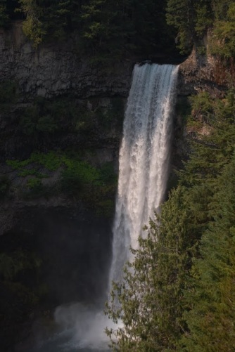
Brandywine Falls in August 2010

Brandywine Falls is one of many great waterfalls that can be found in British Columbia. It is one of the more popular ones, partly because it is relatively tall, and partly because it is so easy to go and see. The hike to the falls could hardly even be considered a hike, more like a short stroll to the viewing area!

Brandywine Falls is found south of Whistler and north of Squamish. It’s not really even that far from Vancouver, depending on where you area. The falls are right off of BC-99 in Brandywine Provincial Park. After parking and paying the $1 (for 1 hour) fee, you’ll be rewarded with the very easy and enjoyable walk to the falls.

Now, there’s a major viewing area that was built for the falls, but this was not my favorite viewpoint. First off, in order to get a good view of the falls, you essentially have to hang over the side of the viewpoint, and you can see 200 or so feet below you. Not great for someone that doesn’t care for heights! Even then, I had to kink my neck to get a good picture. I would check that viewpoint out, but I’d also suggest heading to a viewpoint that is further along the very short trail. This other viewpoint is not designated, but I think it leads to just as good, if not better view of the falls more head-on. There is a tree blocking the very lowest portion, but I didn’t mind. Walking further along also leads to great views of the valley below.

Directions:

  1. Brandywine Falls is found between Squamish and Whistler along BC-99. If heading north, the entrance to the park will be on your right. As a “warning”, the entrance to the falls can be confusing, especially if heading south. It’s not all that apparent what road your supposed to follow to enter the park or to leave it (at least in certain directions).
  2. After parking and paying, hike to the falls.

Accessibility: 10/10 (easy)
Height: 230′
Length of Hike: 0.6 miles round-trip

Where in the World is Brandywine Falls?