
Quick Facts
Accessibility: 3/10 (moderate/difficult, from Minnesota), 9/10 (easy, from Ontario)
Height: 15′ / 5 m
Hike: 5.0-mile / 8.0 km hike round-trip (in Minnesota), 0.5 miles / 0.8 km round-trip (in Ontario)
The Record
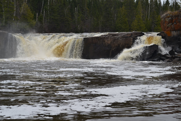
The Pigeon River, which serves as a rugged border between Minnesota and Ontario, is home to the famous High Falls. For those willing to look a little further, the Middle Falls offers a completely different experience. Interestingly, your enjoyment of Middle Falls might depend entirely on which country you’re standing in. On the Minnesota side, within Grand Portage State Park, reaching these falls is a commitment. Unlike the easy boardwalk to High Falls, Middle Falls requires a 2.5 to 3-mile hike one-way over uneven, steep terrain. While it’s a great workout and offers a sense of solitude, it can be a bit of a letdown to hike that far only to find a waterfall that is significantly smaller and less dramatic than its “High” neighbor.
However, if you cross the border into Ontario, the experience is transformed. When I visited the Ontario side near Thunder Bay in late April 2012, I discovered that what was a strenuous trek in Minnesota is a mere stroll in Canada. The hike from the Ontario parking area is only about a quarter-mile, a fraction of the distance. The only tricky part is finding the trailhead; there isn’t a large sign, and I actually drove past it before my hunch told me to turn around. Not only is the access easier, but I found the views from the Ontario side to be superior. In fact, the perspective was so different that for a moment, I wasn’t even sure I was looking at the same waterfall!
Whether you choose the Minnesota or Ontario side depends on what you’re looking for. If you want a rugged hike through the woods and the quiet of a less-traveled path, the Minnesota side is a solid choice. But if you want the best views with the least amount of effort, the Ontario side is undoubtedly the way to go. Just keep a sharp eye out for that small parking area once you cross the border, as it’s easy to miss.
Directions
From Minnesota
- Head north on MN-61 from Grand Portage to the entrance of Grand Portage State Park. You’ll see the border gate as you’re turning in.
- From the parking area, start along the trail toward High Falls. You should be heading west.
- Instead of heading toward High Falls, continue along the Middle Falls Trail. It is at least 1.6 miles one-way. Near the end of the trail, the trail splits (and creates a circle). The left fork in the trail leads you to the falls quicker, and I would even return from that direction. The right fork adds a longer distance, and didn’t hold any interest for me.
From Ontario
- On ON-61, find Route 593. Head west on Route 593, where, after about 1 mile (maybe even less), you’ll pass a parking area on your LEFT. It’s really the only parking area, so turn in. If you’re unsure, there’s a sign in the parking area to indicate you’re near the falls.
- Walk along the old road upstream to the falls.
Where in the World is Lower Middle Falls?


Leave a comment