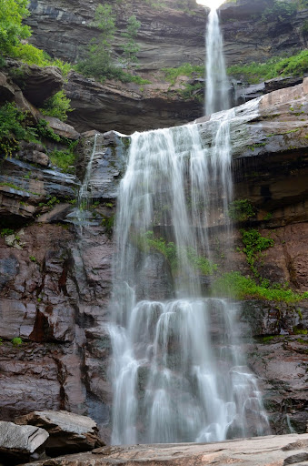
Kaaterskill Falls in July 2014
I know some people try to visit waterfalls at the “perfect time”, when the sun is at the perfect position or it’s a cloudy day. I don’t always have that option, and so sometimes I show up at the “wrong time”, when the sun is directly above the falls and it’s really difficult to get a good photograph. That was the case with Kaaterskill Falls, one of the more popular waterfalls in eastern New York. At 260′ tall, that’s where it gets most of its fame.
There are beautiful paintings and pictures of Kaaterskill Falls, but I really had a much harder time capturing the falls in all of its possible glory. The sun wasn’t helping, and honestly, to get the pictures that others had painted, I would have had to be standing in some very odd location. I’m not even sure what location that would have been, as the trees blocked most of the viewpoints that would have allowed me to see both drops at their appropriate magnitude.
Instead, I ended up with a much closer view of the lower portion of the falls, while the bottom piece of the upper drop could not be captured. I had to be standing on the left side of the river at the base just to capture this much of the falls without having the photo completely ruined by the sun. I guess I really didn’t love Kaaterskill Falls as much as I thought I would because of these issues. The hike to the falls wasn’t extremely difficult, but I think I was expecting something visually different.
Directions:
- I did not take the exit from I-87 to get to the falls, so I don’t really know what exit you would take, considering it’s a toll road with limited exits. I instead started on US-9W, and turned onto NY-23A heading east at the junction of these two roads.
- Continue heading east along NY-23A, passing under I-87. Keep going along 23A past the junction with NY-32.
- NY-23A will start climbing uphill with some sharp, curvy turns. At some point along the road, the speed limit is reduced drastically, you will take an extremely sharp curve, crossing the bridge over Kaaterskill Creek. If you look to your right, you’ll see Bastion Falls.
- Pass over that bridge, and shortly after that (about 0.2 miles or so), you’ll come to a parking area on your left. It could be very easy to pass, so pay careful attention. If you pass this, I’m not sure when the next place to turn around is.
- From the parking area, you will then have to head back to the bridge and Kaaterskill Creek. This is along the curvy, winding road, and at times you will be walking along a road with absolutely no shoulder. Be extremely careful.
- Cross over the bridge, and the start of the trail should be to your left. (You would be heading upstream.) You’ll know you’re in the right place since there’s a sign for Kaaterskill Falls.
- Start the hike. The first few hundred feet are actually the steepest, and then it tends to level out somewhat. It’s only about 0.5 miles one-way from the start of the trail.
Don’t Be Stupid Alert!: It’s not difficult to arrive at the base of the lower drop, but climbing to the base of the upper drop is extremely dangerous. There are signs indicating to not hike past a certain point, but there’s an obvious trail where people have ignored these signs. Don’t do it! Don’t be stupid!
Accessibility: 6/10 (moderate)
Height: 260′
Distance of Hike: 1 mile round-trip
Where in the World is Kaaterskill Falls?
