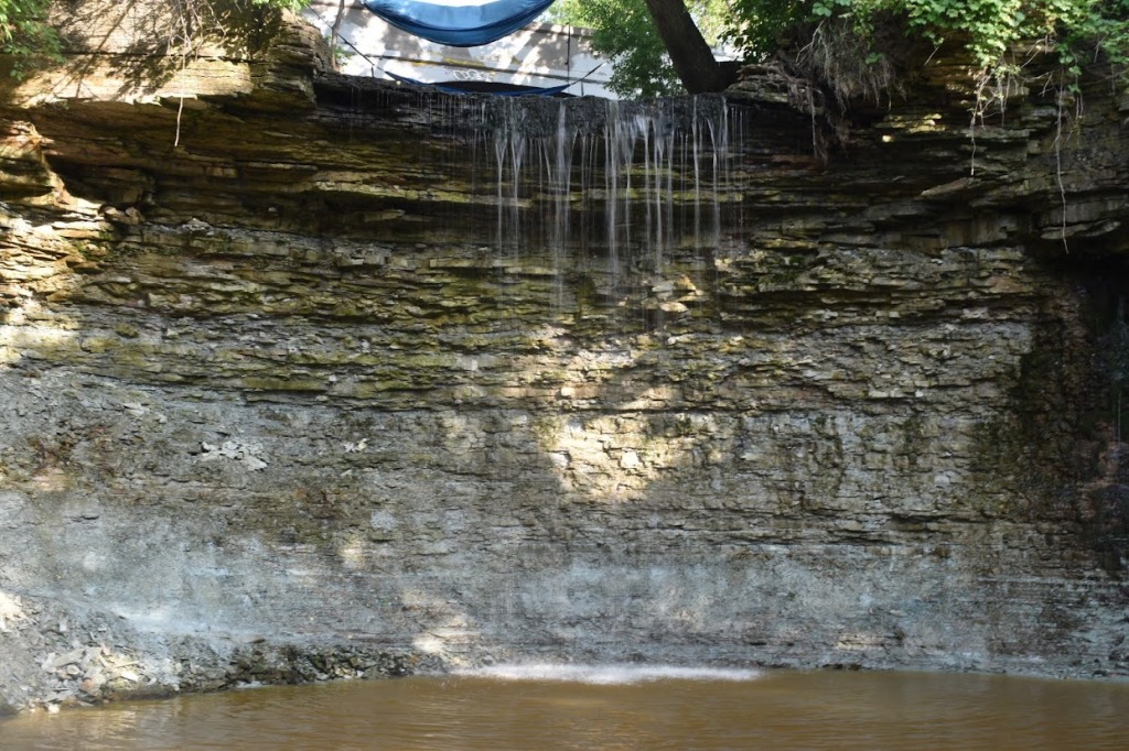
Fonferek Falls, Wisconsin

Fonferek Falls in June 2022

There are a few waterfalls very close to Green Bay. One is Wequiock Falls, which is northeast of Green Bay. A bit southeast of the city is Fonferek Falls. Wequiock Falls is closer to the lake, so to me it had more of that type of vibe, playful with swings above the falls. Fonferek Falls has a more country feel.

The trail to Fonferek Falls starts at a house with a barn, though don’t trespass! As you walk along, the country feel builds. Even though there wasn’t much water flowing at the falls, there’s definitely some farm runoff that flows into the creek because there’s a farm smell. Not bad, just adds to the vibe!

There are multiple views of the falls. When you first get to the falls, it’s a good view, but it’s fun to explore more. I would guess that at times where there’s a lot of water flowing, the options may be more limited. When we visited, we were able to cross the creek without much difficulty and check out the left side of the falls. And even there, there are more options to explore. We found some walking paths that headed downhill to the base of the falls and were able to get that view also. The picture here is from the base of the falls. The whole top of the falls is very beautiful, but in those pictures, it’s hard to tell where the waterfall is. Fonferek Falls might be best to visit after a good rainfall or after the snow starts melting.

Directions:

  1. Fonferek Falls is not far from I-43. Whether heading north or south on I-43, you can take exit 178.
  2. From exit 178, turn south on Elm View Road. Drive along Elm View Road, which then veers to the right and turns into Dutchman Road.
  3. Continue along Dutchman Road (County Road MM) until you reach the sign for Fonferek’s Glen Brown County Park. If you’re headed west, the road will be on your right.
  4. The turn is for Memory Lane, which quickly dead ends at the house/barn and trailhead. Respect the private property here. Follow only the trails that lead to the falls.

Accessibility: 8/10 (easy/moderate)
Height: 30′
Distance of Hike: 0.2 miles round trip

Where in the World is Fonferek Falls?

Wequiock Falls, Wisconsin

I thought I had posted about Wequiock Falls earlier in the year, but here we are. In June, we went to the Upper Peninsula of Michigan and ended up in the “thumb” of the UP. I was trying to decide how to get home and figured I would take the ferry from Manitowoc, WI to Ludington, MI. We drove down to Green Bay for the night. I knew there were a few waterfalls in the area.

Depending on the Google maps source, it was reported that Wequiock Falls was closed, but it wasn’t. Unless the path is blocked off, I’m not sure how the park could be closed. There isn’t much infrastructure there to close. After reading a Google review, I expected the park to be trashed, but was pleasantly surprised to find that it was pretty clean. There were some fast food wrappers before we got to the stairs that lead down to a view of the falls, but it wasn’t what I would classify as trashed. Someone may have shown up at a time where someone hadn’t cleaned up in a while?

Getting to the parking area for the falls is pretty easy, and then hiking to the falls is also not very complicated. There are some stairs that lead down to a viewing area. The viewing area is not great for viewing the falls, and so we walked closer to the falls.

We visited on June 21, 2022, and I guess much of the water from snowmelt had already found it’s way to Lake Michigan…There wasn’t a whole lot of water flowing over the falls. I think it had rained the day before (or hours before), but it still wasn’t a lot. It may benefit you to go in early spring or after a really good rainfall.

Directions:

  1. From Green Bay, head east/northeast on WI-57 (toward what we’ll call the thumb of Wisconsin).
  2. After a few miles, you’ll reach the intersection of WI-57 and VanLaanen Road. If you’re headed east, you’ll turn left onto VanLaanen Road.
  3. The parking area for the falls is a very sharp right after you turn. There are signs to indicate where you should head.
  4. After parking, you’ll head a bit further east. You should be able to see a smaller bridge that leads over a creek. You’ll be passing over the falls.
  5. You’ll head a 100-200 feet along that path and then you’ll come to a staircase. The staircase will lead you down to the creek. There is a viewing deck that’s not that great.
  6. You can head upstream. I didn’t find it to be difficult.

Accessibility: 10/10 (easy)
Height: 25′
Distance of Hike: 0.1 miles round trip

Wequiock Falls in June 2022

Where in the World is Wequiock Falls?

Cascade Falls, Wisconsin

If you live near Minneapolis/St. Paul, Cascade Falls right across the border in Wisconsin is an easy waterfall to visit. It’s found in the city/village of Osceola. When you arrive in Osceola, you park on Cascade Street/Wisconsin-35 near a number of shops and restaurants. Then you head to the trail, which leads you into Wilke Glen and to Cascade Falls.

Cascade Falls is definitely a worthwhile waterfall to visit. It’s big enough and in a beautiful setting to make a point of stopping. The hike does involve some stairs to get you from the street down into the glen, but once you’re down in the glen, you get to see a 25′ tall, rather wide waterfall. It might actually be taller or have more drops, but the way the waterfall turns, it’s hard to see above the main drop.

Once you’ve seen the waterfall, you can keep walking along the trail. It doesn’t lead anywhere wildly exciting, though you can get some cool views of the St. Croix River and the bridge crossing the river which connects Minnesota and Wisconsin.

Directions:

  1. Head toward Osceola, which you can get to from WI-35 or MN-95.
  2. Once you reach Osceola, you can find parking along the main stretch in town, which is WI-35, also called Cascade Street. A landmark that may help is the Watershed Cafe.
  3. Just north of the Watershed Cafe, you’ll find some information signs telling you about Wilke Glen and the falls, and there will be stairs leading downhill. After you finish climbing down the stairs, the waterfall will come into view on the left.

Accessibility: 7/10 (easy/moderate due to the stairs)
Height: 25′
Length of Hike: 0.2 miles round-trip

Cascade Falls in September 2019

Where in the World is Cascade Falls?

Willow Falls, Wisconsin

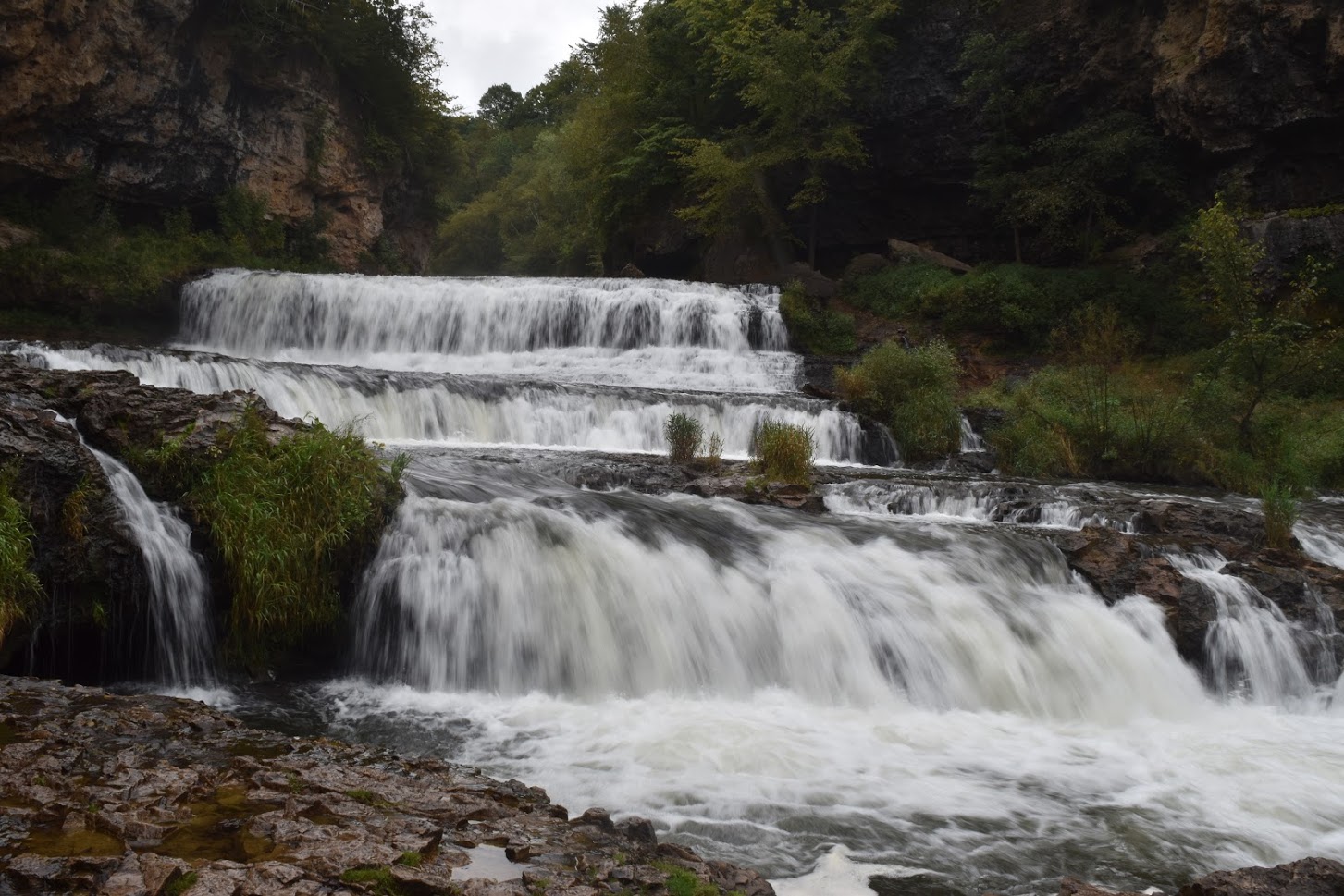
A couple of years ago, I flew into Minneapolis and visited a number of waterfalls. One of the Minnesota waterfalls I visited was Vermillion Falls in Hastings. I for some reason didn’t realize that there were other waterfalls very close to the Minnesota/Wisconsin border, or at least that these waterfalls were so close. Willow Falls is only about 30 minutes away from Hastings, and Cascade Falls is only about 30 minutes from Willow Falls. So there are a number of other waterfalls along the border that you might want to check out.

Willow Falls is definitely a waterfall that you want to check out. While it is a bit isolated from other waterfalls, it is a beautiful waterfall. There are a number of different trails that lead to the main trail to the falls, but the shortest way to get there is via a specific parking lot designated for the falls. The hike starts out pretty easily, but then becomes rather steep, though it is paved. That makes the hike a bit more moderate in difficulty, especially on the way back to the parking lot. But when you reach the falls, you’re rewarded with a really nice tiered waterfall that approaches 45′ in height and 100′ wide. There are a few different viewpoints that lead to great shots of the falls.

Directions:

  1. Headed in from Minneapolis/St. Paul, you might be headed east on I-94.
  2. Take exit 4 (in Wisconsin) for County Road U (US-12), and head north on US-12.
  3. Instead of veering east on US-12, continue forward along County Road U, which then turns into County Road A.
  4. Willow Falls State Park is found on the left of the road if you’re headed north. Maps online seem to indicate that you can head directly to the Willow Falls parking area, but that is blocked off. You must enter at the park entrance and pay the fee. You will then follow a dirt road to the parking area. (I don’t know if this changes based on the season?)
  5. From the parking area, follow signs for the falls. You’ll know you’re headed in the right direction if you’re on a moderately steep, paved path.

Accessibility: 7/10 (moderate)
Height: 45′
Length of Hike: 0.6 miles round-trip

Willow Falls (113)

Willow Falls in September 2019

Where in the World is Willow Falls?

Bridal Veil Falls, Iowa

Bridal Veil Falls in July 2014

As I said in a post about Malanaphy Spring Falls, one doesn’t really expect to find many waterfalls in Iowa. And honestly, there aren’t a whole lot, though there are still more than one might expect. Malanaphy Spring Falls was flowing very well in June of 2014, but Bridal Veil Falls wasn’t flowing very well.

When I visited the area, it was relatively warm, and at that point, any water source for the falls had mostly (though not all) dried up. And maybe there really isn’t ever much water flowing over the falls. I have to admit I don’t know if I’d go out of my way to see the falls (unless I knew there had been a lot of rain recently). And yet, I also have to admit that Pike Peaks State Park (where Bridal Veil Falls is found) is a really beautiful park. There are great views of the Upper Mississippi River from a 500′ bluff. So…if you decide to stop, then the trek along the stairways through the park is enjoyable as you discover Bridal Veil Falls.

Directions:

  1. From US-18 right near the Iowa/Wisconsin border (on the Iowa side), take the exit before you head over the Upper Mississippi River into Wisconsin.
  2. Head south along 1st Street. You’ll pass the Lady Luck Riverboat Casino if you’re headed in the right direction.
  3. At some point, 1st Street will turn into River Street, which will then turn into Main Street.
  4. Pass through the town of McGregor. Main Street will come to and end, and you will have to turn left onto Walton Street.
  5. After turning left, you will very quickly after turn right onto Clayton County Road 56.
  6. Drive along Clayton County Road 56 to the entrance of the park. (You want the entrance on Pike Peak Road. You will turn left on this road.)
  7. Drive to the parking area, and then obtain a map to help you find the falls. If I remember correctly, the signs to the falls are pretty clear.

Accessibility: 8/10 (easy/moderate)
Height: 10′
Length of Hike: Less than 1 mile round trip (multiple possible paths)

Where in the World is Bridal Veil Falls?

Amnicon Falls #2, Wisconsin

I am a bit surprised I haven’t already posted about this waterfall along the Amnicon River in Amnicon Falls State Park. I think it may be due to the way I named it on my photo site. It’s a smaller waterfall, but I’ll still mention it nonetheless.

Amnicon Falls State Park is one of those locations that is just plain enjoyable to explore. You’ll find a surprising number of waterfalls in the park: Upper Falls, Lower Falls, Amnicon Falls #1 and #3, Snake Pit Falls, and Now and Then Falls. You’ll find these along different trails. Amnicon Falls #2 is just another of the falls you’ll find!  And while you’re in the area, also check out Pattison State Park, where you’ll find Big Manitou Falls and Little Manitou Falls.

Directions:

  1. From Duluth/Superior, head east on US-2.
  2. Just after the intersection of US-2 with WI-53, you’ll notice a sign indicating that Amnicon Falls State Park is coming very soon.
  3. At the sign indicating the park, turn left onto County Road U.
  4. After a very short distance on County Road U, you will find the entrance for the state park. Stop and purchase a day pass if you need one. The ranger at the visitor’s center was extremely helpful at directing me to the falls and telling me how to get to Pattison State Park.
  5. Right near the visitor center, you can head right down a rather narrow park road to the end of the road, where you’ll find a parking area just a few feet from the river. Head upstream to find the unnamed falls.

Accessibility: 9/10 (easy, more for the confusing loop of trails than anything else)
Length of Hike: 0.5 miles or so (can be longer)
Height: 6′

Amnicon Falls #2 in May 2010

Where in the World is Amnicon Falls #2?

Upper Falls, Wisconsin

I’ve always wished people could become a little bit more creative when naming waterfalls. Upper Falls does clearly describe that is a waterfall further upstream along the Amnicon River, but it’s just not that exciting from a naming perspective! Even “Upper Amnicon Falls” would provide more information about where it’s located, and it could probably be referred to that way! There is the equally as exciting Lower Falls, which is actually pretty cool (as is Upper Falls). If you’re in the same park, there are two falls that were better named, Snake Pit Falls and Now and Then Falls. And then there are other drops that I don’t know if they really have a name, so I’ve called them #1, #2, and #3.

I mention these to indicate what you really get when you visit Amnicon Falls State Park is at least 7 waterfalls! Upper Falls is pretty neat, but you have to take all of them together to appreciate them. It’s a very nice park, and if I had family there, I would totally be taking them there all of the time. It’s really fun to explore all of the trails to find even more falls, even though they aren’t particularly tall. (Upper Falls maybe clocks in at 15′ or so…) And if this doesn’t excite you, don’t forget Big Manitou and Little Manitou Falls aren’t that far away (in Pattison State Park). (Big Manitou clocks in at 165′ tall.)

Directions:

  1. From Duluth/Superior, head east on US-2.
  2. Just after the intersection of US-2 with WI-53, you’ll notice a sign indicating that Amnicon Falls State Park is coming very soon.
  3. At the sign indicating the park, turn left onto County Road U.
  4. After a very short distance on County Road U, you will find the entrance for the state park. Stop and purchase a day pass if you need one. The ranger at the visitor’s center was extremely helpful at directing me to the falls and telling me how to get to Pattison State Park.
  5. Right near the visitor center, you can head right down a rather narrow park road to the end. You’ll see Lower Falls, and then you can head upstream to see Upper Falls.

Accessibility: 10/10 (easy)
Height: 15′
Length of Hike: negligible

Upper Falls in May 2010

Where in the World is Upper Falls?

Snake Pit Falls, Wisconsin

Northern Wisconsin has a number of great waterfalls, and if you’re looking to see a whole bunch in a single hike, then head to Amnicon Falls State Park (which is not that far from Pattison State Park, which contains Big and Little Manitou Falls). Inside Amnicon Falls State Park, there are the not-so-creatively named Upper and Lower Falls, along with other falls along the river (#1 and #3 have been posted). The waterfall with the coolest name, by far, is Snake Pit Falls, and it is a really beautiful waterfall also.

While it does require a little bit of exploring the loop trail, Snake Pit Falls is clearly marked with a sign. It’s hard to say how tall this portion of the falls is. After searching around on the internet, I later discovered there is another drop a few feet after the one shown below. I may have photographed the lower drop during the exploration, but I didn’t seem to notice both drops at the same time. The total drop is somewhere around 20′. I found this particular drop to be very scenic. Each of the drops along the Amnicon River seems to have its own distinct features. It doesn’t look like a series of continuous rapids that blend together over time. I’m guessing the falls flow year-round, except in extremely dry conditions. It had literally just snowed minutes before, lending a certain chilly but appropriate ambiance to the falls.

Directions:

  1. From Duluth/Superior, head east on US-2.
  2. Just after the intersection of US-2 with WI-53, you’ll notice a sign indicating that Amnicon Falls State Park is coming very soon.
  3. At the sign indicating the park, turn left onto County Road U.
  4. After a very short distance on County Road U, you will find the entrance for the state park. Stop and purchase a day pass if you need one. The ranger at the visitor’s center was extremely helpful at directing me to the falls and telling me how to get to Pattison State Park.
  5. Right near the visitor center, you can head right down a rather narrow park road to the end of the road, where you’ll find a parking area just a few feet from the start of the loop trail.

Accessibility: 9/10 (easy)
Height: 20′
Length of Hike: 0.2 miles round-trip

Snake Pit Falls in May 2010

Where in the World is Snake Pit Falls?

Peterson Falls, Michigan/Wisconsin

Just outside of Ironwood and Hurley are two waterfalls found within a short distance of each other. The short distance between the two has created a significant amount of confusion about the identity of the falls. Some books have referred to the falls as Interstate Falls, while others called it Peterson Falls, or both at the same time! It ends up that Peterson Falls is the upstream waterfall, while Interstate Falls is downstream.

I’ve visited Peterson Falls twice, and the visits could not have been different. On the first visit August 2008, there was enough water flowing to call it a waterfall, but one could probably rock hop to the Michigan side. You could actually see three separate portions of the falls.

Peterson Falls in August 2008

In September 2010, there had been a significant amount of rain just before visiting. The falls were wildly different. There would have been absolutely no way to rock hop, as the falls were inundated by water. It actually lost a little bit of its character. (I wasn’t even sure where to photograph…)

Peterson Falls in September 2010

It is much easier to visit them from the Wisconsin side, so follow the directions below to ensure you’re standing in Wisconsin! Interstate Falls is to the left on the trails. Peterson Falls is to the right. At one point the trails intersect, but it can be a little bit confusing. Just don’t leave after seeing only one waterfall! They’re very close to each other. And if you’re exerting yourself to see either falls, you’re probably not on the right path. Both falls are very easy to visit.

Directions:

  1. From Ironwood/Hurley, head west on US-2. You will pass from Michigan into Wisconsin.
  2. After a short distance, you will see Center Drive on your right. If you take a look, you will even notice a white sign for one of the falls.
  3. Turn right onto Center Drive, a dirt road, a head down it. At one point, you will veer right.
  4. There is a dirt pit in the area, so that’s likely how you’ll know you’re in the right area. The road is blocked by a small “rock wall”. From this sandy parking area, head down a well-worn trail to the falls.

Accessibility: 10/10 (easy)
Height: 15′
Length of Hike: 0.3 miles round-trip

Where in the World is Peterson Falls?

Dave’s Falls, Wisconsin

Dave’s Falls is one of those waterfalls that I wouldn’t necessarily go out of the way for, except for the fact that it is very easy to visit (if you’re in the vicinity). Wisconsin does have some tall waterfalls. Big Manitou Falls might be one of the tallest in the Great Lakes region. Many of Wisconsin’s waterfalls, though, seem to be smaller. Dave’s Falls is maybe a total of a 20′ drop, but it’s spread out.

As I’ve said, it’s redeeming quality is that it is easy to visit. Some of those smaller waterfalls, such as Twelve Foot Falls, Eighteen Foot Falls, and Horseshoe Falls, require driving down dirt roads for at least a few miles. It’s not that the dirt roads are bad, but they are more isolated. Dave’s Falls, and its upstream counterpart, Upper Dave’s Falls, around found right of US-141 just south of the village of Amberg. And while Dave’s Falls isn’t extremely tall, it is still an interesting drop. Further north along US-141 are Smalley Falls and the very interesting Long Slide Falls.

Directions:

  1. The waterfall is south of Pembine on US-141. If you’re driving south from there, it’s only about 1 mile from the city, and the road to the park will be on your right.
  2. Turn right onto County Park Road, which leads to Dave’s Falls County Park.
  3. The most prominent path leads to the lower falls, so wander upstream to get this view of the upper falls.

Accessibility: 10/10 (easy)
Height: 20′
Length of Hike: 0.2 miles round-trip

Dave’s Falls in June 2009

Where in the World is Dave’s Falls?