
I don’t have many favorites. Each waterfalls is unique, and so I often find it hard to classify waterfalls, or other things in general, as favorites. But Superior Falls is definitely one of my favorite waterfalls.
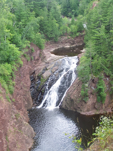
I don’t know if it’s the location or the scenery, but this waterfall is just so intriguing to me. It is found on the Montreal River, which is natural border between Michigan and Wisconsin. The waterfall is viewed from the Michigan side, though it is best accessed by traveling through Wisconsin. It is aptly named, considering that is just hundreds of yards away from Lake Superior. Once you get to the viewing area, you are greeted by a rather tall waterfall. The view is just great, especially considering that most waterfalls don’t look spectacular from above…but this one does. It could be cliffs surrounding the falls that just add even more character and charm.
You can explore the area around the falls, and there are two or three smaller drops upstream that can be viewed close-up. The area around the falls is EXTREMELY steep, but somebody used some logic and put up tall metal fencing that allows for much safer access to the upper areas of the falls. There are signs still indicating you need to be careful, especially in case of the unexpected flash flood.
Update: When I initially visited in August 2008, the waterfall was at relatively low flow, which allowed visitors to see the underlying bedrock. I then visited Superior Falls on September 26, 2010. This was after what was a CONSIDERABLE amount of rainfall in the western Upper Peninsula, which led to a considerably different view, as seen below…

Directions:
- Though the best view of the falls is in Michigan, the easiest way to the falls is through Wisconsin. You will be driving along US-2 in Wisconsin, and you will come to WI-122.
- Turn north onto WI-122. Keep driving on this road.
- At some point, you will enter Michigan, which I believe is clearly marked with a smaller sign.
- After about 1/2 mile from the border, there will be a gravel road on your left leading to a power plant and parking lot. You are allowed to park here.
- Follow the roar of the water to the falls, or head down the steep hill to get a better view of Lake Superior. If you walk to the mouth of the Montreal River and look inward, you can actually glimpse the bottom portion of the falls.
Accessibility: 8/10 (for the simplest viewpoint)
Height: 70′
Length of Hike: 0.1 miles round-trip
Where in the World is Superior Falls?

Leave a comment