
I read that the hike to Wahclella Falls was easy, but that’s dependent on many factors. In Oregon, easy is different than in other, flatter places. It also depends on whether you’ve hiked to see other waterfalls just before that. It’s not a hard hike by any means, but it does have some inclines that can wear you out. They’re definitely don’t provide the same workout as some of the other hikes in the area, hence why it’s probably considered “easy.”
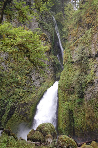
Wahclella Falls is another one of those falls that is overshadowed by its much bigger brother, Multnomah Falls. I like Multnomah Falls, but Wahclella Falls is far more interesting to me. It appeared to be just as voluminous. I was pleasantly surprised at its size.
There is an upper and a lower drop to the falls. The lower drop is easy to photograph, while the upper drop is more difficult. The upper fall that is in the photograph is not the upper portion of Wahclella Falls, but instead the East Fork Creek falling into Wahclella Creek. The two creeks are merging at the point just above the crest of the lower drop. I’ve read that East Fork Falls might not be visible in the summer if it is dry.
Directions:
- From I-84, take exit 40 (Bonneville Dam).
- You can exit from either the east or the west. Wherever you exit from, head away from the entrance to the dam and head toward the gorge.
- After turning, if you go straight, you’ll see a sign indicating trail heads, and then a sign indicating parking for Wahclella Falls. Head here.
- Park in the parking area, which may be rather full on the weekends.
Accessibility: 6/10 (moderate)
Height: 90′
Length of Hike: 1.75 miles round-trip
Where in the World are Wahclella & East Fork Falls?

Leave a comment