
I had the chance to find more waterfalls in Massachusetts, Vermont, and New Hampshire this past weekend. The first waterfall I found was Doane’s Falls. Doane’s Falls consists of three separate drops, and each of them is far enough apart from the previous drop that I’ve decided to write about them as three separate waterfalls.
The first drop you’ll encounter along the river is the easiest to visit, since it is right near the road. You only have to walk a short distance along the trail to view the falls. I have to admit that I was a bit surprised to see the falls flowing so well in late July, but that’s a indication that this is probably a great year-round waterfall.
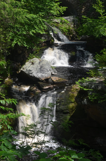
As with the middle of the three falls, the most difficult thing at Doane’s Falls seems to be photographing the whole falls. You might have better luck earlier in spring before any leaves are on the trees. As you may notice, the lower portion of this drop was partially blocked by a pine. And there was no way to get closer to the falls to avoid that, as the area was blocked off with metal ropes. It’s not a huge deal, but you’ll just have to accept you might not be able to get the falls in all of its glory.
Directions:
- From MA-2/US-202 heading west, take exit 18 heading north toward MA-2A. (Heading east, exit 17 may be easier.)
- Turn left onto MA-2A, which at some point combines with MA-32.
- Take this into the town of Athol. Once in Athol, take a right on MA-32 to continue heading north.
- Quickly after turning onto MA-32, take a right onto Chestnut Hill Avenue. (This will be shortly after crossing the bridge over Millers River.
- Drive along Chestnut Hill Avenue (which may change names to Athol Road at some point) for a few miles.
- You will come up to Doane Hill Road. Just before you would turn left onto Doane Hill Road (heading toward Tully Lake), you’ll find the small parking area clearly signed for Doane’s Falls.
- From the parking area, you’ll take a short hike to the Upper Falls.
Accessibility: 10/10 (easy)
Distance of Hike: 0.1 mile round trip (at most)
Height: ~15′ (there are more drops downstream)
Where in the World is Upper Doane’s Falls?

Leave a comment