
I thought I would have written about Feather Falls already. The adventure getting to Feather Falls was definitely interesting, to say the least. Though once I had finally reached Feather Falls, it was definitely worth it!
I probably didn’t pay attention as much to the directions about the loop trail that exists, even as I’m reading it now. Realize there is an upper loop trail at 4.5 miles to the falls, and a lower loop trail at 3.5 miles to the falls. As many people probably think, let’s choose the shorter portion since it will be quicker. It is not, very simply. It is actually much more difficult to hike, at least when I visited in early March 2016. The lower loop trail seems to be constant up and down, and I would describe that trail as more “rustic”. It had been raining significantly the days before I arrived at the falls, and so the lower loop trail became very muddy, and in some parts had essentially a small but steady stream of water flowing downhill. I was soaked and muddy after doing the lower loop portion first. To get to the viewpoint for Feather Falls, you then steadily climb uphill, though it’s rather short. Unluckily, my knee decided to buckle and there was some definite pain, and I still had to return to the parking area. Luckily, I wasn’t injured where I couldn’t get back.
If I were to go on this hike again, I would absolutely recommend using the upper loop trail for the whole hike. There wasn’t any view on the lower loop trail that was remotely worth the difficulty. The upper loop trail was much more enjoyable, even with a knee in pain. One benefit of the lower loop trail: you can see Brush Creek Falls (or what I’m calling Brush Creek Falls). It’s off in the distance.
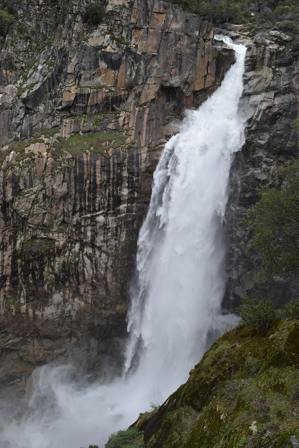
Once you reach the falls, as I mentioned, the whole hike becomes absolutely worth it. At 410′ tall, Feather Falls is stunningly beautiful. The scenery and geology around the falls is amazing. You definitely feel like you’ve entered Yosemite National Park (which isn’t really wildly far away.) So even though it might be a moderate/strenuous hike, it’s still a hike you should do if you love waterfalls!
Directions:
- I stayed in Oroville. If starting from Oroville, head east on CA-162. Drive 4-6 miles on CA-162 east, depending on where you start in Oroville.
- Turn right on Forbestown Road, and drive for 6 miles.
- Turn left onto Lumpkin Road and drive 11 miles.
- Turn left onto Bryant Ravine Road and drive just under 2 miles to the trail head.
- Choose which part of the loop you want to hike, and head to the falls.
Accesibility: 4/10 (Moderate/Strenuous)
Height: 410′
Length of Hike: 7.4 to 9.8 miles round-trip

Where in the World is Feather Falls?

Leave a comment