Unnamed Falls #1, Raymondskill Area, Pennsylvania

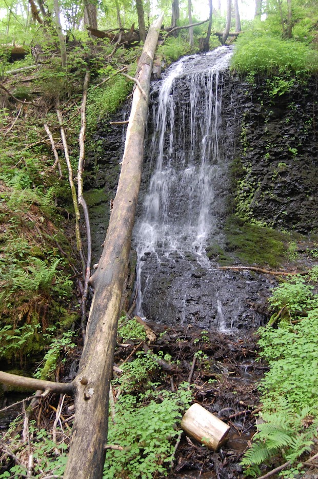
A waterfall near Raymondskill Falls in May 2019

In certain places, there can be a number of different waterfalls…so many so that people don’t know what to do with them all. They may not put them on a map or name them. Raymondskill Creek is one of those areas. I’ve got six waterfalls on the map, though the main focus is impressive falls Raymondskill Falls. I’ve posted about the other five waterfalls, so I’m now at the sixth.

Of course, I visited the falls in 2019, so it’s possible that the paths have changed in the 14 years since I’ve visited. Maybe names have been attached to some of the falls. This and the Unnamed Falls #2 may be ephemeral (seasonal) waterfalls, so it’s possible they may not be as interesting in the depths of the summer. It was warm when I visited in May of that year and there were some intense storms producing some rainfall while I was visiting the area, so it made for some great waterfall viewing.

Directions:

  1. From I-84, take exit 46 to Milford.
  2. Go east on US-6 for a little more than 2 miles.
  3. Go south onto US-209 for 2.5 miles.
  4. Turn right onto Raymondskill Road. Go 0.3 miles to the parking lots. There are two different parking areas, one with a visitor’s center. Park at the first one that you encounter.
  5. From there, the trail will split. Take the trail that heads to the left. It might split again (I can’t remember.). If so, take that left also, and you’ll head downhill on a moderately steep slope. From here you’ll see the falls.

Accessibility: 7/10 (easy/moderate)
Height: ~20′
Length of Hike: 0.4 miles round-trip

Where in the World is Unnamed Falls #1?
Lower Laurel Falls, New Jersey

Lower Laurel Falls in May 2009

New Jersey is another one of those states where you wouldn’t necessarily expect many waterfalls, but there are surprising number of both tall and large waterfalls in the state. Lower Laurel Falls isn’t particularly tall or wide, nor is its upper brother, Upper Laurel Falls. The scenery is particularly beautiful, though, and that makes up for the size.

New Jersey’s border with the Delaware River is very scenic. It is more hilly (mountainous?), and it’s very enjoyable to drive down the roads that wind through the area. The Laurel Falls are found northeast of Stroudsburg, Pennsylvania, and are very easy to get to from that area. As you head to the falls, you’re actually travelling on a very old road that has been used to transport goods for hundreds of years. Once you get to Laurel Falls, you might not necessarily expect anything extremely exciting, but it’s definitely far more worthwhile than I originally imagined.

Directions:

  1. On I-80, take exit #1 (in New Jersey). Depending on whether you’re going east or west, it can be easy or complicated. Going west, it’s just a straight-shoot exit. If you’re going east, you will have to exit at the visitor’s center, loop around, briefly get back on I-80 heading WEST and then take exit #1.
  2. Once you’ve exited, you’ll head north on NJ-606 (Old Mine Road). At one point, you will end up on a one-lane road, so you might have a little wait because of stop lights.
  3. After about 3.8 miles on NJ-606, you’ll reach a campground/parking area on your left. It is for the Worthington State Forest, and there will be a bathroom there, along with a park and camping. Park here, if possible. (On weekends or holidays, it may be VERY difficult to find parking.)
  4. From the parking area, cross the road, and head up the Douglas Trail. Follow the creek there and you’re sure to find the falls.

Accessibility: 7/10 (easy/moderate)
Height: 15′
Length of Hike: 0.5 miles round-trip (to see both falls)

Where in the World is Lower Laurel Falls?

Upper Raymondskill Falls #3, Pennsylvania

Normally, most people only end up visiting Raymondskill Falls, clearly the largest of the falls. Upstream of Raymondskill Falls are three other waterfalls that you should check out too, simply because they’re so nearby. The third waterfall is not considerably exciting, though there is a good view to be had.

It’s definitely an enjoyable hike wandering to this group of falls. The first and third falls have better views than the second fall, which is not at a good angle.

Directions:

  1. From I-84, take exit 46 to Milford.
  2. Go east on US-6 for a little more than 2 miles.
  3. Go south onto US-209 for 2.5 miles.
  4. Turn right onto Raymondskill Road. Go 0.3 miles to the parking lots. There are two different parking areas, one with a visitor’s center. Both trails lead to Raymondskill Falls.
  5. From the uppermost viewpoint of Raymondskill Falls, you’ll see a slope that will lead you upstream. The slope is the most difficult part of the journey, as it is rather slippery.
  6. As you head upstream, follow the river as closely as possible. Be careful, though, as there are some steeper drops.
  7. After a quarter mile or so, you’ll come on the the group of three falls.

Accessibility: 6/10 (moderate)
Height: 15′
Length of Hike: 1 mile round-trip

ra up 3

Upper Raymondskill Falls #3 in May 2009

Where in the World is Upper Raymondskill Falls #3?

Dingmans Falls, Pennsylvania

Dingmans Falls in May 2009

Dingmans Falls is another spectacular waterfall found on the Pennsylvania side of the Delaware Water Gap. Of those waterfalls in the area, Dingmans Falls is one of the easiest to access, and this makes it very popular. It deserves that popularity.

The waterfall is found at the end of a boardwalk leading to the base of the falls. Along the way, you will pass the thinner, but tall, Silver Thread Falls. The boardwalk is handicap accessible. Once you get to the base of the falls, you will see a beautiful combination plunge/cascade waterfall that looks like it’s leaning on its side! It’s a unique waterfall in an area full of waterfalls.

Directions:

  1. As you’re driving along US-209 in Pennsylvania, you will enter the town of Dingmans Ferry. Continue south on US-209 for a short distance.
  2. There will be a sign for Dingmans Falls, and you will turn right onto Johnny B Mountain Road.
  3. Head down Johnny B Mountain Road to the parking lot for the falls.
  4. Head down the handicapped accessible trail. Silver Thread Falls will be the first falls you encounter.

Note about Dingman’s Ferry: This is one of the few places where you can drive into New Jersey across the Delaware River. There are only a few bridges that allow access across the river, so if you’re looking for some waterfalls in New Jersey, this may be a good place to cross. (Buttermilk Falls and other New Jersey waterfalls in the Delaware Water Gap are most easily accessed by crossing this bridge.)

Accessibility: 10/10 (easy)
Height: 75′
Length of Hike: 0.5 miles round-trip

Where in the World is Dingmans Falls?

Unnamed Pond Run Falls, Pennsylvania

The hidden waterfall on Pond Run in Bushkill Falls Park (May 2009)

I have very quickly discovered that we are sometimes very inconsistent in our waterfall reporting.  Sometimes, waterfalls just seem too small to be of interest, especially when there are larger falls nearby.  Other times, the views are just particularly poor (or even non-existent).  The product of this inconsistency is that there are often interesting waterfalls that we just don’t advertise.

Inside the Bushkill Falls Park in the Delaware Water Gap region, there are many major falls.  Along Pond Run, there are a number of interesting falls.  One that hasn’t been named or advertised, though, is this specific waterfall.  I’m guessing that this is simply because trees block getting a very good view of the falls.  Now, I’m not for going and tearing trees down just to get a better view, and I’m not suggesting we should.  But why does this waterfall not get a better viewpoint.  I think it’s very intriguing to ask why this waterfall doesn’t even get recognition while others that were clearly smaller in the park did.

Directions:
1) You can access the Bushkill Falls park from US-209 in Pennsylvania.
2) From US-209, turn onto Bushkill Falls Road near the town of Bushkill.
3) From there, head down that road to the sign for the entrance to the park.
4) Park in the parking lot. The park opens at different times depending on the season, but it is best to arrive as early as possible. It is a very popular attraction.
5) From there, pay the $10 entrance fee, making sure to get a brochure with map. This unnamed waterfall is found above the Bridesmaid and Bridalveil Falls.

Accessibility: 8/10

Where in the World is Unnamed Pond Run Falls?: map

Bridalveil Falls, Pennsylvania

Bridalveil Falls in May 2009

I don’t have much to say about Bridalveil Falls except to reiterate what I’ve likely said before. Bridalveil Falls is found in the Bushkill Falls Park in the Delaware Water Gap region of Northeast Pennsylvania. There is a fee to enter the park, and there is a beautiful trail leading to beautiful views of ten or so waterfalls.

Bridalveil Falls is found in between the two Bridesmaid Falls (#1 and #2). I think it is taller than it appears in the picture. It’s a rather easy hike to the fails, and there are a number of stairs that lead you up and down the trail. While the sign mentions that the red trail can be strenuous, the overall hike is mild in comparison to some other hikes I’ve been on.

Directions:

  1. You can access the Bushkill Falls park from US-209 in Pennsylvania.
  2. From US-209, turn onto Bushkill Falls Road near the town of Bushkill.
  3. From there, head down that road to the sign for the entrance to the park.
  4. Park in the parking lot. The park opens at different times depending on the season, but it is best to arrive as early as possible. It is a very popular attraction.
  5. From there, pay the entrance fee, making sure to get a brochure with map. The map will help you get to Bridesmaid Falls and its wedding partners.

Accessibility: 8/10 (easy/moderate)
Height: 28′
Length of Hike: 2 miles round-trip (to see all falls)

Where in the World is Bridalveil Falls?

Upper Raymondskill Falls #1, Pennsylvania

ra up 1

Upper Raymondskill Falls #1 in May 2009

Normally, most people only end up visiting Raymondskill Falls, clearly the largest of the falls. Upstream of Raymondskill Falls are three other waterfalls that you should check out too, simply because they’re so nearby.

It’s not exactly obvious that these waterfalls are accessible, but they are not terribly difficult to get to. The hardest part is the initial, but very short, climb up a slope that is relatively slippery. After the hike to the falls, you’ll see of the first of the three waterfalls. This is one of the better less advertised waterfalls in the area. I don’t remember how tall it is, but it is surprisingly beautiful. (Here’s more information about Upper Falls #2 and #3.

Directions:

  1. From I-84, take exit 46 to Milford.
  2. Go east on US-6 for a little more than 2 miles.
  3. Go south onto US-209 for 2.5 miles.
  4. Turn right onto Raymondskill Road. Go 0.3 miles to the parking lots. There are two different parking areas, one with a visitor’s center. Both trails lead to Raymondskill Falls.
  5. From the uppermost viewpoint of Raymondskill Falls, you’ll see a slope that will lead you upstream. The slope is the most difficult part of the journey, as it is rather slippery.
  6. As you head upstream, follow the river as closely as possible. Be careful, though, as there are some steeper drops.
  7. After a quarter mile or so, you’ll come on the the group of three falls.

Accessibility: 6/10 (moderate)
Height: 35′
Length of Hike: 1 mile round-trip

Where in the World is Upper Raymondskill Falls #1?

Lower Gorge Falls, Pennsylvania

Bushkill Falls Park has 9 or 10 different waterfalls in the park. After Bushkill Falls, Lower Gorge Falls might be the second largest of the falls. The problem is that it is almost impossible to get a very good view/photograph of this waterfall. I was walking along the red diamond trail and approached Lower Gorge Falls. You’ll get good glimpses of the falls, though trees will be blocking your view enough to prevent a good picture. As you get closer to the falls, there is actually a bridge that crosses over the crest of the falls. This will be your best bet in getting a glimpse of the falls.

  1. You can access the Bushkill Falls park from US-209 in Pennsylvania.
  2. From US-209, turn onto Bushkill Falls Road near the town of Bushkill.
  3. From there, head down that road to the sign for the entrance to the park.
  4. Park in the parking lot. The park opens at different times depending on the season, but it is best to arrive as early as possible. It is a very popular attraction.
  5. From there, pay the entrance fee, making sure to get a brochure with map.

Accessibility: 8/10 (easy/moderate)
Height: 35′
Length of Hike: 2 miles round-trip (to see all falls)

Lower Gorge Falls in May 2009

Where in the World is Lower Gorge Falls?

Unnamed Falls, Worthington State Forest, New Jersey

After trying to find the Great Falls on the Passaic and failing, I had some time to kill. I decided to head back to the Delaware Water Gap area and look for some more waterfalls right near the Delaware River. I was trying to find Laurel Falls and pulled off at the wrong area. As I was looking around, I realized there was a trail that started across the road from where I was and I also heard what sounded like a waterfall. This wasn’t recorded anywhere in the book, but I decided to take a look anyway.

I had parked in a turnoff right near the road leading to the visitors center for Worthington State Forest. I crossed the road, and started exploring. The first path I took did not lead directly to the best view of the falls, but I could tell there was a small waterfall a ways above me. I then walked back down to the road, and headed up a slightly steeper trail to my left. After trudging through a bunch of plants, I finally got a great view of this waterfall. I really like this waterfall, maybe because I found it by myself without the help of any book or map. It was unexpected, and the unexpected can be very cool.

The GPS coordinates for the place I parked were: 41.00477˚N, 75.09867˚W. This may be a little bit off, but it’s the general area where the waterfall was found.

Directions:

  1. On I-80, take exit #1 (in New Jersey). Depending on whether you’re going east or west, it can be easy or complicated. Going west, it’s just a straight-shoot exit. If you’re going east, you will have to exit at the visitor’s center, loop around, briefly get back on I-80 heading WEST and then take exit #1.
  2. Once you’ve exited, you’ll head north on NJ-606 (Old Mine Road). At one point, you will end up on a one-lane road, so you might have a little wait because of stop lights.
  3. As you’re driving along, you’ll come to an entrance for the visitor’s center for Worthington State Forest. (At least I think…it may have been something else, but I think it led to a visitor’s center or to a check-in area?)
  4. A VERY short distance after that, there will be a small pulloff area to your left. Pull off there and you should hear the creek and see a trail that leads in the general direction of the falls.

Accessibility: 8/10 (easy/moderate)
Height: 15′
Length of Hike: 0.2 miles round-trip

An unnamed waterfall in Worthington State Forest (May 2009)

Where in the World is Unnamed Falls?

Bridesmaid Falls #1, Pennsylvania

Alright, so here’s the confusing part. In Bushkill Falls Park, there are two waterfalls on the same creek that are named Bridesmaid Falls (info on #2). I guess when somebody looked at both of them, the first thing they thought about were weddings. Maybe somebody was getting married and they were really excited? There is also a Bridalveil Falls on the same creek.

While Bushkill Falls is the main attraction in the park, you should definitely visit this group of waterfalls, as they are very beautiful. There is an entrance fee, so take advantage of it. The hike around the park is really very nice.

Directions:

  1. You can access the Bushkill Falls park from US-209 in Pennsylvania.
  2. From US-209, turn onto Bushkill Falls Road near the town of Bushkill.
  3. From there, head down that road to the sign for the entrance to the park.
  4. Park in the parking lot. The park opens at different times depending on the season, but it is best to arrive as early as possible. It is a very popular attraction.
  5. From there, pay the entrance fee, making sure to get a brochure with map. The map will help you get to Bridesmaid Falls and its wedding partners.

Accessibility: 8/10 (easy/moderate)
Height: 18′
Length of Hike: 2 miles round-trip (to see all falls)

Bridesmaid Falls #1 in May 2009

Where in the World is Bridesmaid Falls?